Quantcast
ZME Science
  • News
  • Environment
  • Health
  • Future
  • Space
  • Features
  • More
    • About
    • The Team
    • Advertise
    • Contribute
    • Our stance on climate change
    • Privacy Policy
    • Contact
No Result
View All Result
ZME Science

No Result
View All Result
ZME Science
No Result
View All Result
Home Science Geology

Tsunami Warning Lifted After Magnitude 7.8 Quake Off Indonesia

Mihai Andrei by Mihai Andrei
March 3, 2016
in Geology, News
Reading Time: 1 min read
A A
Share on FacebookShare on TwitterSubmit to Reddit

Indonesian authorities lifted a tsunami warning issued after a magnitude 7.8 earthquake struck off the island of Sumatra – the largest earthquake since the 2004 disaster.

The U.S. Geological Survey said the epicenter was about 500 miles west-southwest of Padang, Indonesia and 529 miles north-northwest of the Cocos Islands. Source: USGS

“There is no info on casualties or damages yet,” Sutopo Purwo Nugroho, a spokesman at the national disaster mitigation agency, said via text message. “The tsunami warning is based on modeling, while tsunami buoys in Indonesian waters haven’t reported any existence of a tsunami. Many buoys are broken and not functioning, so we don’t know whether the potential for a tsunami in the waters is true or not.”

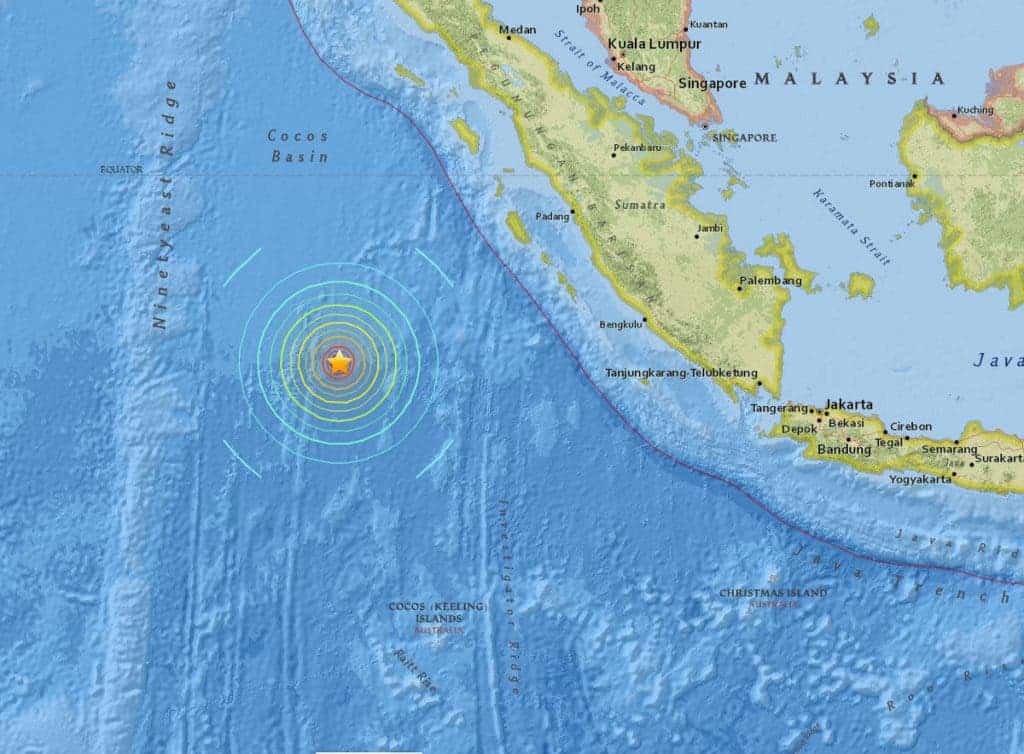
According to the United States Geological Survey, the earthquake struck at 19:49 local time (12:49 GMT). It said the epicentre was 805km (500 miles) south-west of the city of Padang, and 24km deep.

Sorry to interrupt, but you should really...

...Join the ZME newsletter for amazing science news, features, and exclusive scoops. More than 40,000 subscribers can't be wrong.


Thankfully, there seems to be no damage caused by the earthquakes and any tsunamis should have already hit by now, so the coast seems to be safe for now. Telephone communication was reported to be down in the Mentawai island chain, which is closer to the epicenter.

ADVERTISEMENT

The tectonics of Indonesia are very complex, as it is a meeting point of several tectonic plates, which makes it one of the most active earthquake hotspots in the world. In 2004, a massive 9.1 magnitude earthquake struck Indonesia, with the resulting tsunami killing 230,000 people in 14 countries, and inundating coastal communities with waves up to 30 metres (100 ft) high. It was one of the deadliest natural disasters in recorded history.

ADVERTISEMENT

Tags: earthquakeindonesiatsunami
ShareTweetShare
Mihai Andrei

Mihai Andrei

Andrei's background is in geophysics, and he's been fascinated by it ever since he was a child. Feeling that there is a gap between scientists and the general audience, he started ZME Science -- and the results are what you see today.

ADVERTISEMENT
ADVERTISEMENT
  • News
  • Environment
  • Health
  • Future
  • Space
  • Features
  • More

© 2007-2019 ZME Science - Not exactly rocket science. All Rights Reserved.

No Result
View All Result
  • News
  • Environment
  • Health
  • Future
  • Space
  • Features
  • More
    • About
    • The Team
    • Advertise
    • Contribute
    • Our stance on climate change
    • Privacy Policy
    • Contact

© 2007-2019 ZME Science - Not exactly rocket science. All Rights Reserved.