Telecom cables are getting a second job: analyzing earthquake data to map the subsurface.
Much of what we know about our planet’s interior comes from earthquakes. Whenever an earthquake happens, it sends out waves that we can detect using special instruments called seismometers. Based on the way these waves propagate, geophysicists can then infer various properties and structures from the subsurface. But precise seismometers can be expensive to install and manage, and researchers are increasingly looking at an unlikely alternative: fiber optic cables.
Fiber optic cables are the backbone of modern internet — they’re what give you high-speed internet (if you’re fortunate enough to have high-speed internet, that is). These cables are virtually identical to regular electric ones, with one key difference: they have one or more optical fibers that are used to carry light. Herein lies the key to their usage as seismometers.
When an earthquake happens, it makes the cables vibrate, and it changes the way light propagates through the cable. Researchers can monitor how these pulses scatter as they travel through the cable, calculating small changes in the fiber material. The first, simple application is that the method can be used to detect earthquakes, but a more finessed application is that you could use the information from seismic waves to “map” the subsurface (essentially mapping specific properties of the subsurface).
It’s not the first time something like this has been proposed. It’s been a pretty hot topic in the seismology community for the past few years, especially in California. In the new study, researchers used an approach of using distributed acoustic sensing (DAS) to construct a high-resolution image of the first few hundred meters of the subsurface.
There’s another advantage to this method: you don’t necessarily need an earthquake for it to work; if you have something else that produces vibrations, that too can work. Although the louder the vibrations the better, it can work with all sorts of vibrations. For instance, the method was used to monitor the changes in car traffic during COVID-19 lockdowns and even to name the loudest marching band at the 2020 Rose Parade.
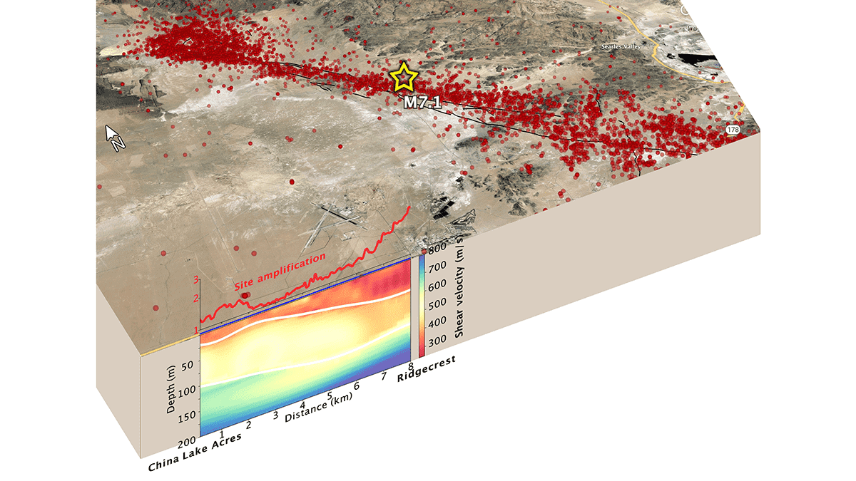
The study, led by Yan Yang Caltech Seismological Laboratory, used DAS to monitor vibrations coming from the traffic. They then used the data to create a shear velocity model that was around 100 times higher resolution than models obtained with typical data. This model showed that along the length of the fiber, the areas of more ground motion generally corresponded with areas where shear velocity was lower.
Previous studies have shown that ground shaking is amplified in some geological structures, but mapping these structures has proved challenging DAS promises to be an affordable and high-accurate method that could be put to great use in mapping urban earthquake hazards, the researchers conclude.
The study was published in Geophysical Research Letters.


