The Øresund Bridge isn’t simply a “bridge”. Or rather, it’s more than just a bridge. It’s a combined two-level, road-and-rail bridge, an artificial island, and a tunnel. It’s a feat of engineering that begins as a tunnel on the Danish side, emerges onto an artificial island, and then soars into a seemingly never-ending bridge towards Sweden. The Øresund Bridge was an opportunity for engineers to push the boundaries of their field. This is its story.

The bridge between Denmark and Sweden
The Øresund Strait separates the Zealand island of Denmark from the southern province of Scania in Swedem. It’s 4 kilometers (2.5 mi) at the narrowest point between Kronborg Castle at Helsingør in Denmark — not at all easy to overcome. But this couldn’t stop these Scandinavian countries. They designed a magnificent bridge that turns into a tunnel… let me explain.
The idea for a bridge over the Øresund Strait first starts in the early 20th century. In 1910, the Swedish Parliament started discussing the concept of a bridge. The project was deemed too ambitious and a project was only formally proposed in 1936. A consortium of engineering companies from Denmark made the proposal. They wanted a national motorway that would include this bridge. However, this idea was abandoned as well.
For several decades, a bridge between Denmark and Swedenwas proposed, cancel, reproposed, and recancelled.
The main challenge for the two countries was creating an engineering project that could succeed in the very difficult environment of the strait. There were other challenges as well: making it in a way that’s economically feasible, and ensuring that the fragile environment in the area isn’t severely disrupted.

People from both countries were concerned about the environment. These concerns were so important that they came to play a key role in the bridge’s construction. Ultimately, the bridge project was only feasible with a heavy environmental focused.
What resulted was a remarkable design. The solution? Not just a bridge, but a tunnel too — and an island.
Øresund bridge gets built
The Øresund bridge was designed by the Danish engineering firm COWI and the main architect was George K.S. Rotne. The project started in 1995 and was completed in 1999.
There were two big setbacks. The first was caused by the discovery of 16 unexploded World War II bombs on the seafloor. Understandably, these had to be securely removed and disarmed before work could continue. The other setback was caused by an inadvertently skewed tunnel segment. Nevertheless, the bridge-tunnel-island was finished three months ahead of schedule.
Its use started in 2000. The bridge is currently operated jointly by both states.
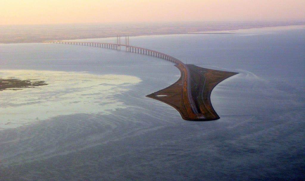
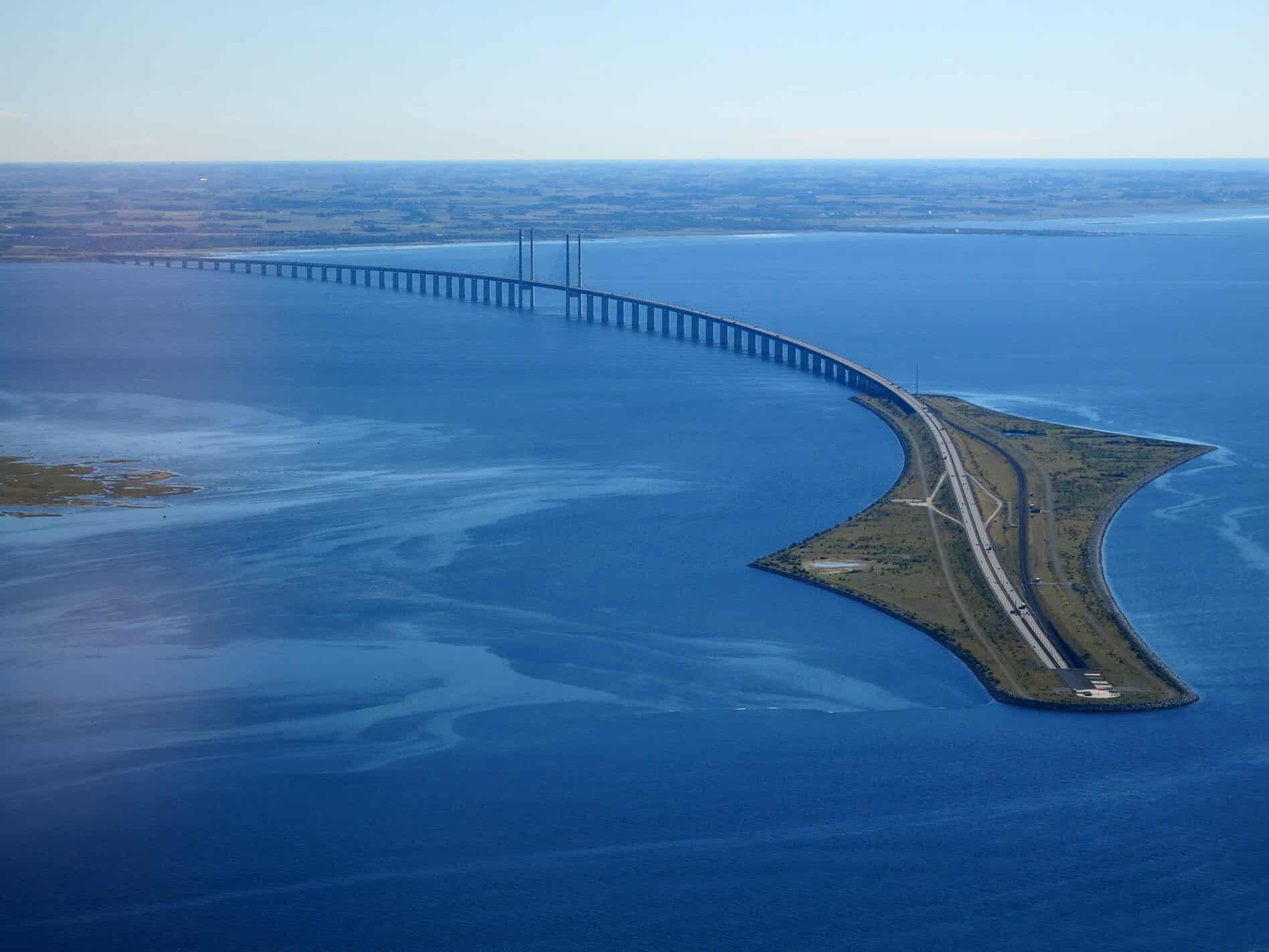
The Øresund Bridge runs nearly 8 kilometers (5 miles) from the Swedish coast to the artificial island of Peberholm, which lies in the middle of the strait. The crossing of the strait is completed by a 4 km (2.5-mile) underwater tunnel, called the Drogden Tunnel, from Peberholm to the Danish island of Amager.
Navigating the Bridge-Tunnel
As you approach from the Danish side, your journey starts with a 4km tunnel, known as the Drogden Tunnel. This was built to avoid interfering with flights from nearby Copenhagen airport and to protect marine wildlife. The tunnel, composed of prefabricated sections, was submerged and laid onto the seafloor — a game of massive underwater Tetris.
Then, you reach Peberholm, an artificial island named after its natural sibling: Saltholm (‘peber’ is Danish for ‘pepper’, while ‘salt’ is, well, ‘salt’). This island, a tranquil rest stop for migrating birds, marks the transition from tunnel to bridge.
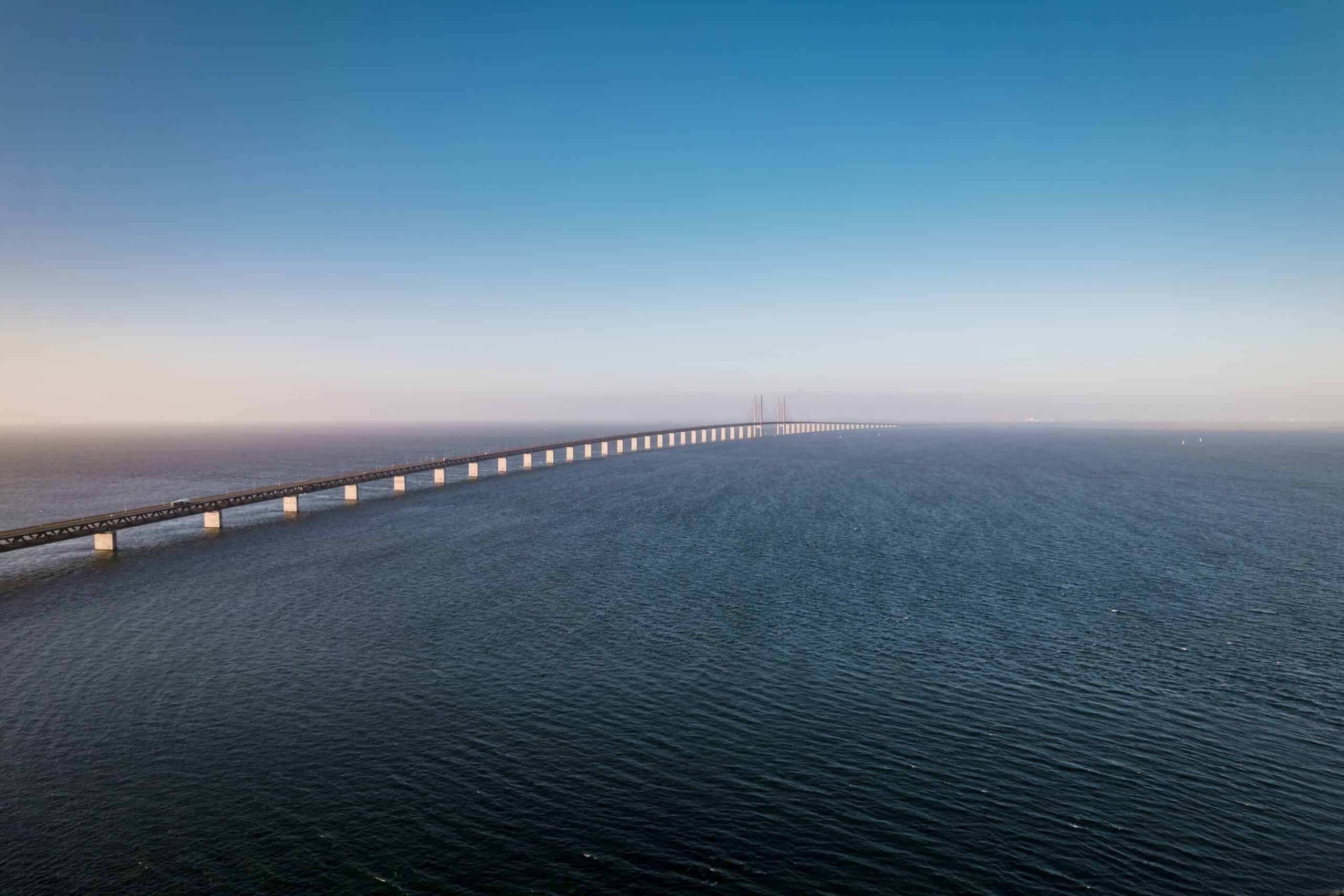
Finally, the spectacular 8km bridge part itself, a cable-stayed marvel that carries you across the strait and into Sweden. The two monumental pylons reaching into the sky are not just for aesthetics; they carry the weight of the bridge via numerous steel cables, making the entire structure lightweight yet strong.
Building the Oresund Bridge was not just about linking two points via highway. It was about movement, about allowing the seamless flow of traffic between two countries. Practically, had to accommodate not only cars but also trains.
For this, the bridge was designed with two decks. The upper deck is for cars, with four lanes allowing vehicles to zip across at speeds up to 90km/hr. Below, a double-track railway lets trains glide across the strait at up to 200km/hr, bringing passengers from Copenhagen to Malmo in just minutes.

Building for nature
The construction of the bridge was a lot about working in harmony with nature, rather than against it. Both Denmark and Sweden agreed to include a tunnel and an artificial island to protect the marine life of the Oresund Strait.
The man-made island of Peberholm is quite spectacular in itself. It was constructed from material dredged from the seabed. Engineers gave the flora and fauna a lot of attention, allowing them to develop freely.
The island has now become a big point of interest for biologists. In fact, only biologists are able to inspect the natural part of the island. The Lund’s Botanical Association has identified more than 500 different species of plants, as well as a popular breeding ground for birds and a habitat for the rare green toad.
Peberholm, the artificial island, has become a sanctuary for flora and fauna. Initially, biologists only planted a few grasses to stabilize the island, but nature quickly took over. It’s now home to over 500 species of plants and serves as a nesting site for many birds.
Since 2008, both the number of birds and the number of bird species have been steadily increasing. The island is largely inhabited by several kinds of breeding gulls, and some locally threatened species are also using the island.

A bridge for the ages
The Øresund Bridge is the longest combined road and rail bridge in Europe. It connects two of the most important centers in the region: the Danish capital of Copenhagen, and Sweden’s city of Malmö. It connects the road and rail networks of the Scandinavian Peninsula with those of Central and Western Europe.
The cable-stayed bridge has two 204-meter-high pylons (almost 700 feet), supporting the bridge across the channel. Thanks to the bridge, an area that now houses 3.7 million people was allowed to develop economically and thrive.
The Oresund Bridge has become more than just a bridge. It’s a symbol of unity, a testament to the power of collaboration and innovation. It has opened new possibilities for travel, business, and cultural exchange, making the Oresund region one of the most dynamic in Scandinavia.
For engineers around the world, it serves as an inspiring example of what can be achieved when human ingenuity meets technical prowess and environmental concern. The bridge between Denmark and Sweden is truly a wonder of engineering.
Was this helpful?


