ZME Science
No Result
View All Result
ZME Science
No Result
View All Result
ZME Science

Home → Science → News

NASA’s study of the Louisiana Deltas yields fantastic images of new land being born

Always down for some eye candy.

Alexandru MicubyAlexandru Micu
February 9, 2017 - Updated on February 10, 2017
in Geology, News, Science
A A
Share on FacebookShare on TwitterSubmit to Reddit

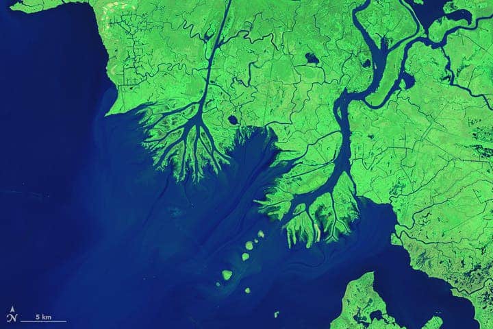
A NASA team showed that aircraft-mounted instruments such as radar or lidar can be used to study the development of growing deltas. Using this method they followed the evolution of the Atchafalaya basin’s coastline, where two river deltas are growing into the Gulf of Mexico, over the last 30 years.

Image credits NASA / Earth Observatory.

Louisiana is sinking

Well, it’s actually subsiding under the Gulf of Mexico’s waters at a rate of about 18 sq miles (46.6 sq km) each year. But two areas of the coast are refusing to go down — Atchafalaya River and its diversion channel, Wax Lake Outlet, each have growing deltas that gain 1.5 and 2 square miles every 11 and 8 hours respectively.

This area has been under intense observation last fall, as a team from NASA’s Jet Propulsion Laboratory in Pasadena used radar, lidar, and a host of other aircraft-mounted instruments to study the growing deltas. Their work proves that airborne observation of such environments is possible and can be accurate while collecting data helps scientists better understand how coasts respond to a rising sea level.

Deltas have been lying around ripe for observation for a long time now, so we have a pretty good understanding of the basic mechanisms that power their growth. But even NASA finds it “hard to do research in a swamp”, so there’s a lot we still don’t understand — the effect different vegetation types have on their development, or what role tides and currents play.

“These factors are usually studied using boats and instruments that have to be transported through marshy and difficult terrain,” said Christine Rains, assistant flight coordinator for the program at JPL.

“This campaign was designed to show that wetlands can also be measured with airborne remote sensing over a large area.”

Mapping the delta

The Louisiana coastline with the two growing deltas, Wax Lake and Atchafalaya, circled in red. The Mississippi River flows to the east of the delta (righ-most blue squiggly line).
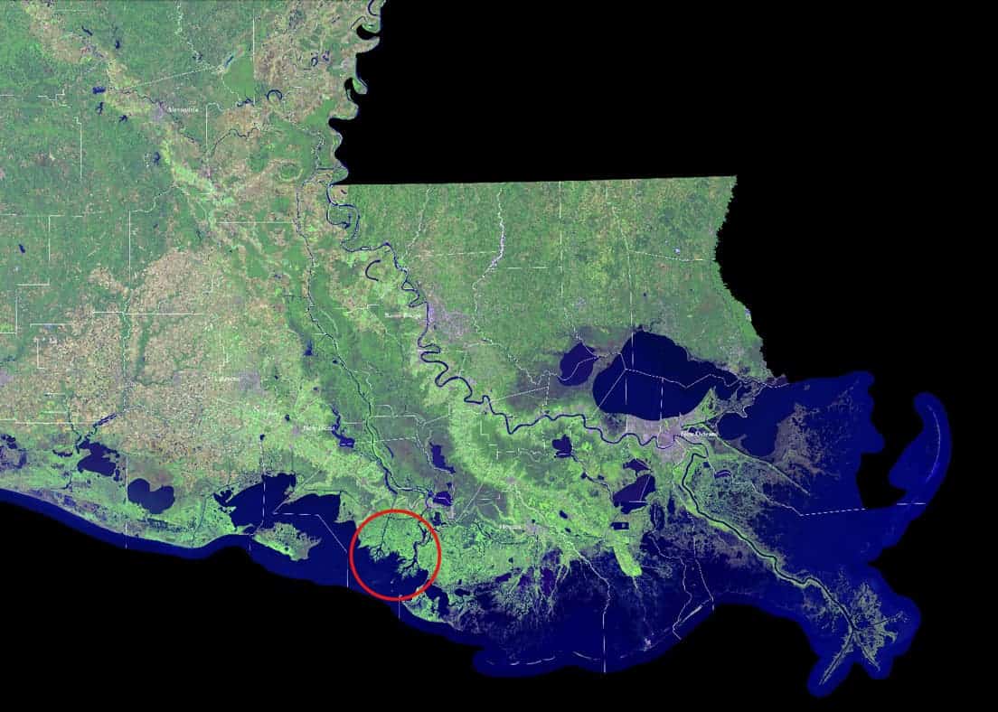
Image credits USGS / NASA.

At least once a year, JPL researchers do a fly-over of the Louisiana coast to track subsidence changes and keep an eye out on the levees. So last fall, they re-tasked these flights to focus on observing the growing deltas, especially vegetation and water flow patterns. They did this because, in a delta, water doesn’t flow one way — it flows in every direction. Incoming tide pushes water into the swampy lowland and can send water back uphill.

“Water flows not only through the main channels of the rivers but also through the marshes,” explained JPL’s Marc Simard, principal investigator for the campaign.

As the tide recedes, this water carries organic-rich sediment from the marshes into the river. JPL’s project measured these flows during both rising and falling tides. It also recorded the slope of the water and mapped the riverbed — which control the rivers’ flow speeds — from its origin in the Mississippi River all the way to the ocean.

The results show that airborne monitoring of deltas is feasible, and yields high-resolution results. It also highlighted that some species of marsh vegetation are more resistant to the flow of water than others.

RelatedPosts

Today marks 55 years since Sputnik’s iconic orbit
NASA announces lunar landing site for the VIPER rover
NASA requests $1 billion in funding for Artemis mission to take man back to the moon by 2024
Miami dredging caused “extensive coral mortality and critical habitat loss” for the US’ only continental reef

“We were really surprised and impressed by [the findings]. In some places, the water changes by 10 centimeters [4 inches] in an hour or two. In others, it’s only three or four centimeters [1 to one-and-a-half inches]. You can see amazing patterns in the remote sensing measurements.”

The next step is to use these measurements to improve models of how water flows through marshlands. These models form the backbone of our predictions on how coastal marshes will cope with global sea level change.

“Our models will have to catch up with the observations now,” Simard added.

The slideshow NASA put together with the deltas’ growth over the past 30 years is pure eye candy, so check it out:

[button url=”http://earthobservatory.nasa.gov/Features/WorldOfChange/wax_lake.php” postid=”” style=”btn-danger” size=”default” target=”_self” fullwidth=”false”]Take me to NASA![/button]


Tags: AtchafalayaDeltaDepositiongulf of mexicoLouisianaMississippinasasediment

ShareTweetShare
Alexandru Micu

Alexandru Micu

Stunningly charming pun connoisseur, I have been fascinated by the world around me since I first laid eyes on it. Always curious, I'm just having a little fun with some very serious science.

Related Posts

Future

NASA Captured a Supersonic Jet Breaking the Sound Barrier and the Image Is Unreal

byTibi Puiu
2 months ago
News

NASA’s Curiosity Rover Spotted Driving Across Mars From Space for the First Time

byTibi Puiu
2 months ago
Climate

Trump’s Budget Plan Is Eviscerating NASA and NOAA Science

byMihai Andrei
2 months ago
News

Astronauts are about to grow mushrooms in space for the first time. It could help us live on Mars

byTibi Puiu
3 months ago

Recent news

Women Rate Women’s Looks Higher Than Even Men

June 14, 2025

AI-Based Method Restores Priceless Renaissance Art in Under 4 Hours Rather Than Months

June 13, 2025

Meet the Dragon Prince: The Closest Known Ancestor to T-Rex

June 13, 2025
  • About
  • Advertise
  • Editorial Policy
  • Privacy Policy and Terms of Use
  • How we review products
  • Contact

© 2007-2025 ZME Science - Not exactly rocket science. All Rights Reserved.

No Result
View All Result
  • Science News
  • Environment
  • Health
  • Space
  • Future
  • Features
    • Natural Sciences
    • Physics
      • Matter and Energy
      • Quantum Mechanics
      • Thermodynamics
    • Chemistry
      • Periodic Table
      • Applied Chemistry
      • Materials
      • Physical Chemistry
    • Biology
      • Anatomy
      • Biochemistry
      • Ecology
      • Genetics
      • Microbiology
      • Plants and Fungi
    • Geology and Paleontology
      • Planet Earth
      • Earth Dynamics
      • Rocks and Minerals
      • Volcanoes
      • Dinosaurs
      • Fossils
    • Animals
      • Mammals
      • Birds
      • Fish
      • Amphibians
      • Reptiles
      • Invertebrates
      • Pets
      • Conservation
      • Animal facts
    • Climate and Weather
      • Climate change
      • Weather and atmosphere
    • Health
      • Drugs
      • Diseases and Conditions
      • Human Body
      • Mind and Brain
      • Food and Nutrition
      • Wellness
    • History and Humanities
      • Anthropology
      • Archaeology
      • History
      • Economics
      • People
      • Sociology
    • Space & Astronomy
      • The Solar System
      • Sun
      • The Moon
      • Planets
      • Asteroids, meteors & comets
      • Astronomy
      • Astrophysics
      • Cosmology
      • Exoplanets & Alien Life
      • Spaceflight and Exploration
    • Technology
      • Computer Science & IT
      • Engineering
      • Inventions
      • Sustainability
      • Renewable Energy
      • Green Living
    • Culture
    • Resources
  • Videos
  • Reviews
  • About Us
    • About
    • The Team
    • Advertise
    • Contribute
    • Editorial policy
    • Privacy Policy
    • Contact

© 2007-2025 ZME Science - Not exactly rocket science. All Rights Reserved.