A striking new video released by NASA shows how the surface of the planet transforms over 20 years of changing seasons.
“It’s like watching the Earth breathe. It’s really remarkable*,” said NASA oceanographer, Jeremy Werdell, in a statement.
“It’s like all of my senses are being transported into space, and then you can compress time and rewind it, and just continually watch this kind of visualization,” he added.
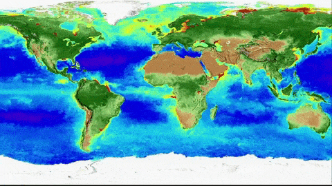
Scientists constructed the visualization with data compiled from September 1997 to September 2017. These twenty years have been condensed in two-and-a-half minutes of mesmerizing imagery that shows how Earth’s surface ebbs and flows with the seasons.
In this dance of the seasons, you can witness how Earth’s vegetation changes. By monitoring the color of reflected light via satellite, scientists can determine how successfully plant life is photosynthesizing, which can be highly important when assessing biosphere health.
Polar ice caps and snow cover extends and retreats while oceans transition from shades of blue and green into hues of red and purple as marine life blooms or goes under. The algae bloom of 1997-1998 is particularly striking, having turned sizable areas of the Pacific into a bright green, spurred by a water-warming El Nino merged with a cooling La Nina.
https://www.youtube.com/watch?v=81MxQzxve3c
It took three months of hard work to complete the visualization of satellite imagery but in the end, it was all worth it. Now, policymakers, but also businesses like commercial fishermen, can use these resources in their decision-making process.
This is only the beginning. Like the seasons, NASA’s visualization will only change. Engineers will improve their renditions with each new version as more and better remote-sensing satellites making into Earth’s orbit.


