Quantcast
ZME Science
  • News
  • Environment
  • Health
  • Future
  • Space
  • Features
  • ZME & more
    • About
    • The Team
    • Advertise
    • Contribute
    • Our stance on climate change
    • Privacy Policy
    • Contact
No Result
View All Result
ZME Science

No Result
View All Result
ZME Science
Home Science News

NASA maps the devastation of Beirut blast from outer space

The effects of the explosion have now been mapped from space.

by Tibi Puiu
August 10, 2020
in News, Space
Share on FacebookShare on TwitterSubmit to Reddit

On August 4, disaster struck Beirut. A stockpile of 2,750 tons of ammonium nitrate, a chemical used as fertilizer or as an ingredient in bombs, suddenly exploded with a force twenty times greater than that of the GBU-43/B Massive Ordnance Air Blast (also known as the “Mother of All Bombs”), the most powerful non-nuclear weapon in the US arsenal.

At least 135 people were killed and more than 4,000 were injured by the massive explosion that produced a 3.3 magnitude earthquake, which was felt as far as Cyprus, around 240 kilometers (150 miles) away.

The toll of this devastation was recently analyzed by NASA scientists, in collaboration with colleagues from the ESA and Singapore, who employed satellite-derived synthetic aperture data to map the extent of the damage in the Lebanese capital.

NASA’s ARIA team, in collaboration with the Earth Observatory of Singapore, used satellite data to map the extent of likely damage following a massive explosion in Beirut. Credit: NASA/JPL-Caltech/Earth Observatory of Singapore/ESA.

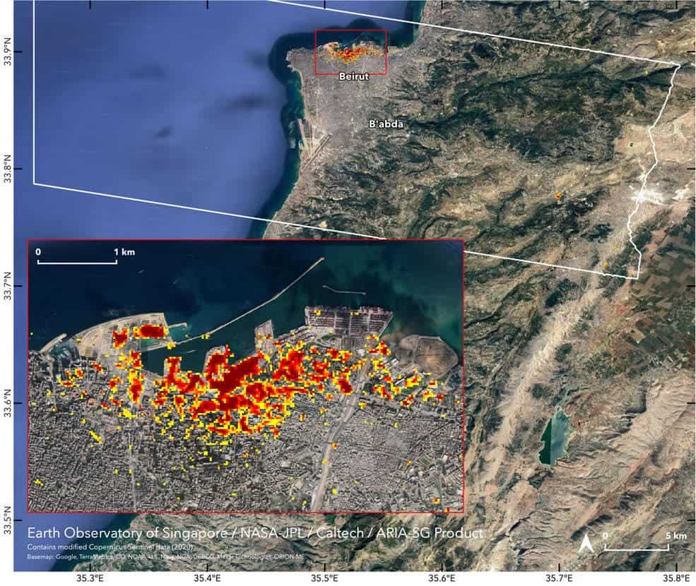
Dark red pixels — each covering an area of 30 meters across — represent the most severe damage. These are typically clustered around the blast’s epicenter, the Port of Beirut. Orange pixels represent moderate damage while yellow pixels correspond to areas that sustained less damage.

This gives a sense of scale to the videos/damage on the ground. NASA imaging shows Beirut blast footprint, news article from the #NASA_App https://t.co/UMUtPgVpvq

— Rob Mayeda (@RobMayeda) August 10, 2020

The destruction in Beirut is thought to have left more than 300,000 people homeless at a time when the country is struggling both financially and politically.

Hopefully, maps such as this can help local authorities identify which areas have suffered the most damage and where people are most in need of assistance.

Tags: beirutexplosionnasa

ShareTweetShare
ADVERTISEMENT
ADVERTISEMENT
  • News
  • Environment
  • Health
  • Future
  • Space
  • Features
  • ZME & more

© 2007-2021 ZME Science - Not exactly rocket science. All Rights Reserved.

No Result
View All Result
  • News
  • Environment
  • Health
  • Future
  • Space
  • Features
  • ZME & more
    • About
    • The Team
    • Advertise
    • Contribute
    • Our stance on climate change
    • Privacy Policy
    • Contact

© 2007-2021 ZME Science - Not exactly rocket science. All Rights Reserved.

Don’t you want to get smarter every day?

YES, sign me up!

Over 35,000 subscribers can’t be wrong. Don’t worry, we never spam. By signing up you agree to our privacy policy.