Quantcast
ZME Science
  • News
  • Environment
  • Health
  • Future
  • Space
  • Features
    Menu
    Natural Sciences
    Health
    History & Humanities
    Space & Astronomy
    Technology
    Culture
    Resources
    Natural Sciences

    Physics

    • Matter and Energy
    • Quantum Mechanics
    • Thermodynamics

    Chemistry

    • Periodic Table
    • Applied Chemistry
    • Materials
    • Physical Chemistry

    Biology

    • Anatomy
    • Biochemistry
    • Ecology
    • Genetics
    • Microbiology
    • Plants and Fungi

    Geology and Paleontology

    • Planet Earth
    • Earth Dynamics
    • Rocks and Minerals
    • Volcanoes
    • Dinosaurs
    • Fossils

    Animals

    • Mammals
    • Birds
    • Fish
    • Reptiles
    • Amphibians
    • Invertebrates
    • Pets
    • Conservation
    • Animals Facts

    Climate and Weather

    • Climate Change
    • Weather and Atmosphere

    Geography

    Mathematics

    Health
    • Drugs
    • Diseases and Conditions
    • Human Body
    • Mind and Brain
    • Food and Nutrition
    • Wellness
    History & Humanities
    • Anthropology
    • Archaeology
    • Economics
    • History
    • People
    • Sociology
    Space & Astronomy
    • The Solar System
    • The Sun
    • The Moon
    • Planets
    • Asteroids, Meteors and Comets
    • Astronomy
    • Astrophysics
    • Cosmology
    • Exoplanets and Alien Life
    • Spaceflight and Exploration
    Technology
    • Computer Science & IT
    • Engineering
    • Inventions
    • Sustainability
    • Renewable Energy
    • Green Living
    Culture
    • Culture and Society
    • Bizarre Stories
    • Lifestyle
    • Art and Music
    • Gaming
    • Books
    • Movies and Shows
    Resources
    • How To
    • Science Careers
    • Metascience
    • Fringe Science
    • Science Experiments
    • School and Study
    • Natural Sciences
    • Health
    • History and Humanities
    • Space & Astronomy
    • Culture
    • Technology
    • Resources
  • Reviews
  • More
    • Agriculture
    • Anthropology
    • Biology
    • Chemistry
    • Electronics
    • Geology
    • History
    • Mathematics
    • Nanotechnology
    • Economics
    • Paleontology
    • Physics
    • Psychology
    • Robotics
  • About Us
    • About
    • The Team
    • Advertise
    • Contribute
    • Privacy Policy
    • Contact
No Result
View All Result
ZME Science

No Result
View All Result
ZME Science

Home → Features → Pieces

Satellite images show the massive extent of August’s wildfires

Fires are ravaging many parts of the world.

Mihai Andrei by Mihai Andrei
August 23, 2021
in Climate, Pieces, Remote sensing

It’s been a scorching summer, and it’s no coincidence. With climate change in almost full swing, the odds of heatwaves and fires increase dramatically — and we’re seeing the effects. The European Union’s Copernicus observation program has published a collage of just some of these fires, as seen from space. Here are some of them.

Table of contents

  • 1 Wildfires in north-eastern Algeria
  • 2 Wildfire in Evia, Greece
  • 3 Carbon monoxide pollution from wildfires on North America’s West Coast
  • 4 Smoke cloud from fires in Amazonia
  • 5 Wildfire in Var, France
  • 6 More fires in Greece
  • 7 Wildfire near Castro Marim – Portugal
  • 8 The bottom line: wildfires and global warming go hand in hand

Wildfires in north-eastern Algeria

Credit: European Union, Copernicus Sentinel-2 imagery.

This 3D visualization shows one of the dozens of fires ravaging through the Kabylia region in Algeria. Thousands of fires have broken out in the Mediterranean, and over 100 of them are in the Kabylia region, where there have been  65 casualties to date.

Algerians have decried the lack of governmental support as the fires rip through the country.

“We started raising funds and volunteering during the last COVID-19 wave, so a lot of organisational mechanisms were already in place to fight these fires,” said Mokrane Nessah, a 54-year-old coordinator for one of the charities on site.

Wildfire in Evia, Greece

Credit: European Union, Copernicus Sentinel-2 imagery.

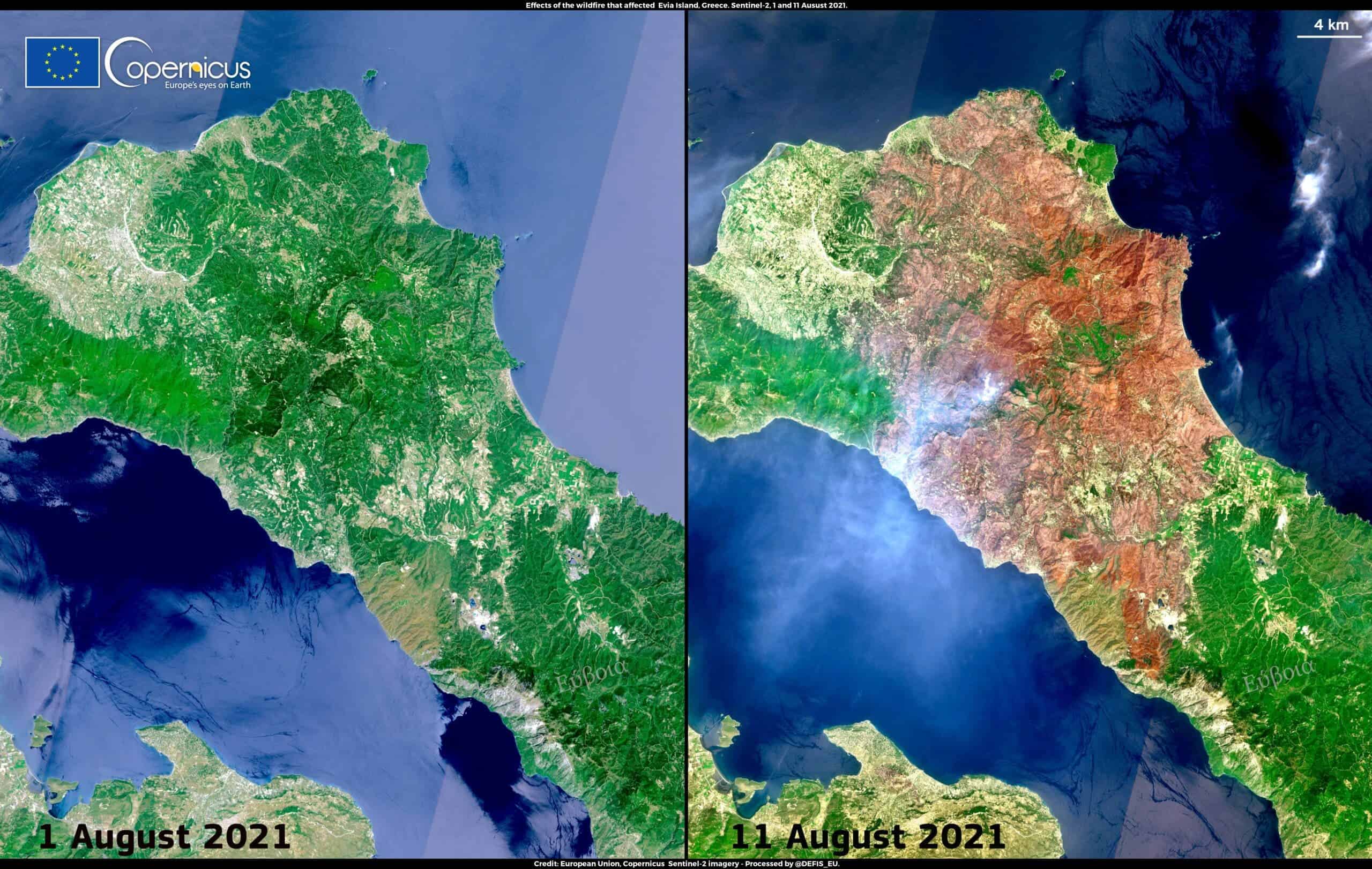
Evia is the second-largest Greek island, and these two images taken just ten days apart show how the island was devastated by wildfires. Thousands of residents were evacuated, and after tireless firefighter work, the fire was contained only after seven days.

Carbon monoxide pollution from wildfires on North America’s West Coast

Credit: European Union, Copernicus Sentinel-5P imagery.

Many of the dreadful effects of wildfires are visible to the naked eye — but not all. Heatwaves across North America have fueled massive wildfires (so-called “megafires”). According to data from the Copernicus Atmosphere Monitoring Service, these megafires have triggered massive carbon dioxide emissions. Many of these fires are still not contained.

Smoke cloud from fires in Amazonia

Credit: European Union, Copernicus Sentinel-3 imagery.

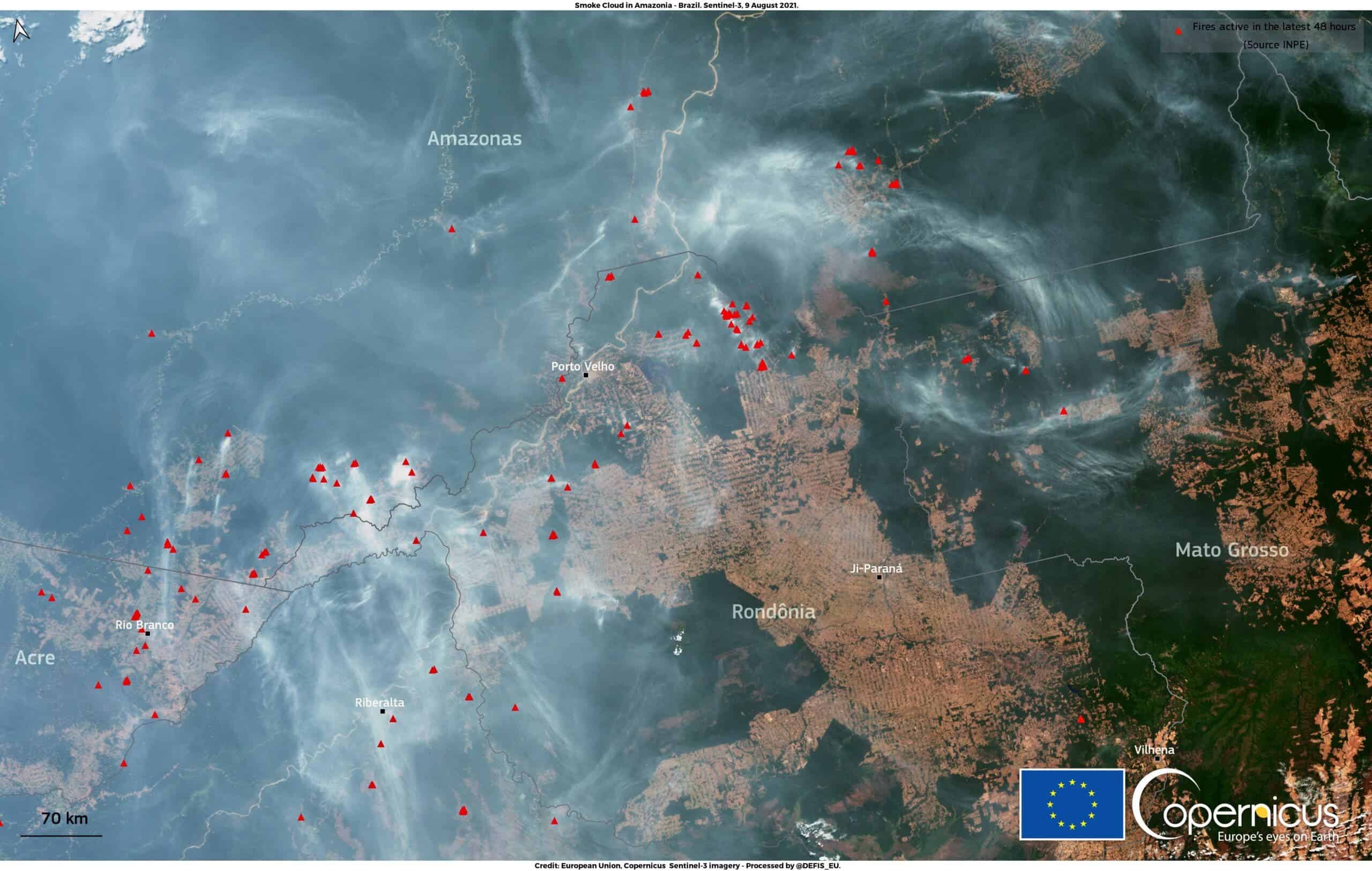
Every year, the fire season in the Amazon peaks in August-September. While some fires are natural, in recent years, the phenomenon is greatly exacerbated by burning of vegetation for deforestation. Recently, the Brazilian Institute of Space Research (INPE) recorded the second-highest annual deforestation rate ever. According to its data, in the period between August 2020 and July 2021, Brazil has lost 8,712 km² of forests, or about 12 times the area of New York City. 

This smoke cloud is visible from some of the areas most affected by deforestation — the states of Rondônia, Mato Grosso, and Para.

Wildfire in Var, France

Credit: European Union, Copernicus Sentinel-2 imagery.

The Mediterranean basin has been hit by one of its most severe heatwaves in history. A fire broke out in south-eastern France, causing thousands to evacuate their homes or holiday sites. In the image above, the fire scar is still visible, while active fires still output smoke.

More fires in Greece

Credit: European Union, Copernicus Sentinel-2 imagery.

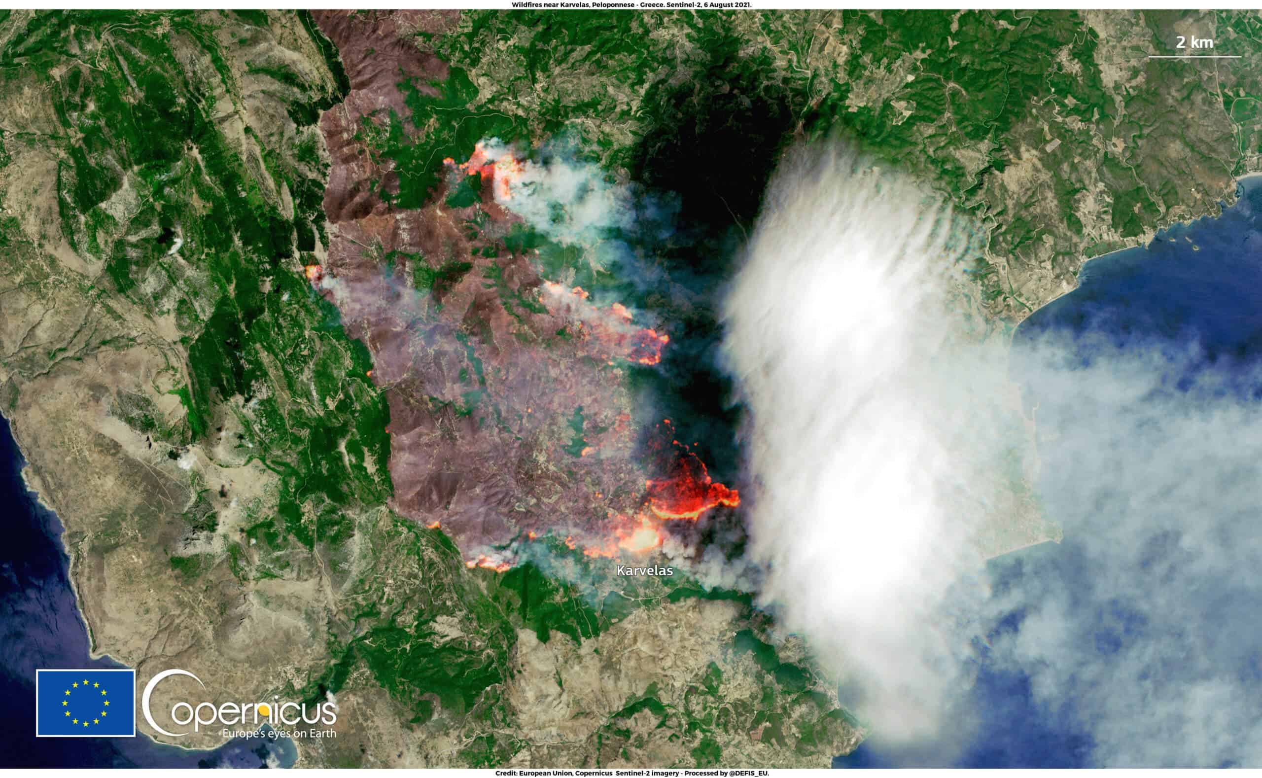
Greece is having a particularly painful wildfire year. The image above shows a fire in Peloponnese, also fueled by intense heatwaves and strong winds. Heatwaves cause leaves and wood to be drier and more flammable.

Credit: European Union, Copernicus Sentinel-3 imagery.

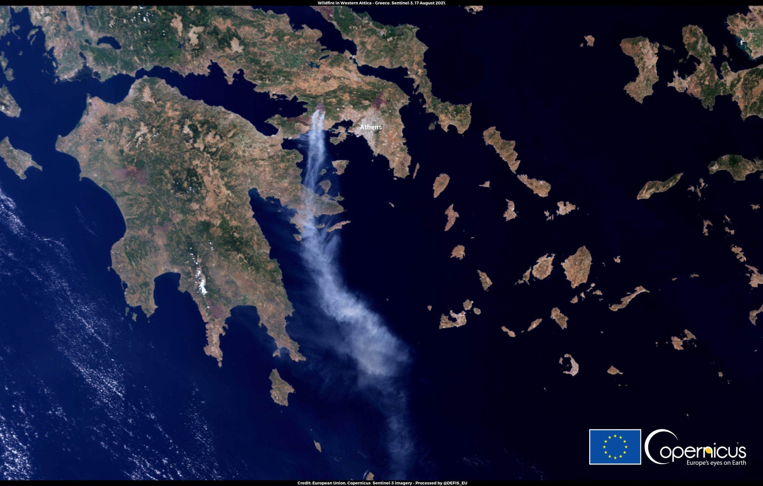
Meanwhile, in western Attica, very strong winds are making firefighter intervention much more difficult.

Wildfire near Castro Marim – Portugal

Credit: European Union, Copernicus Sentinel-2 imagery.

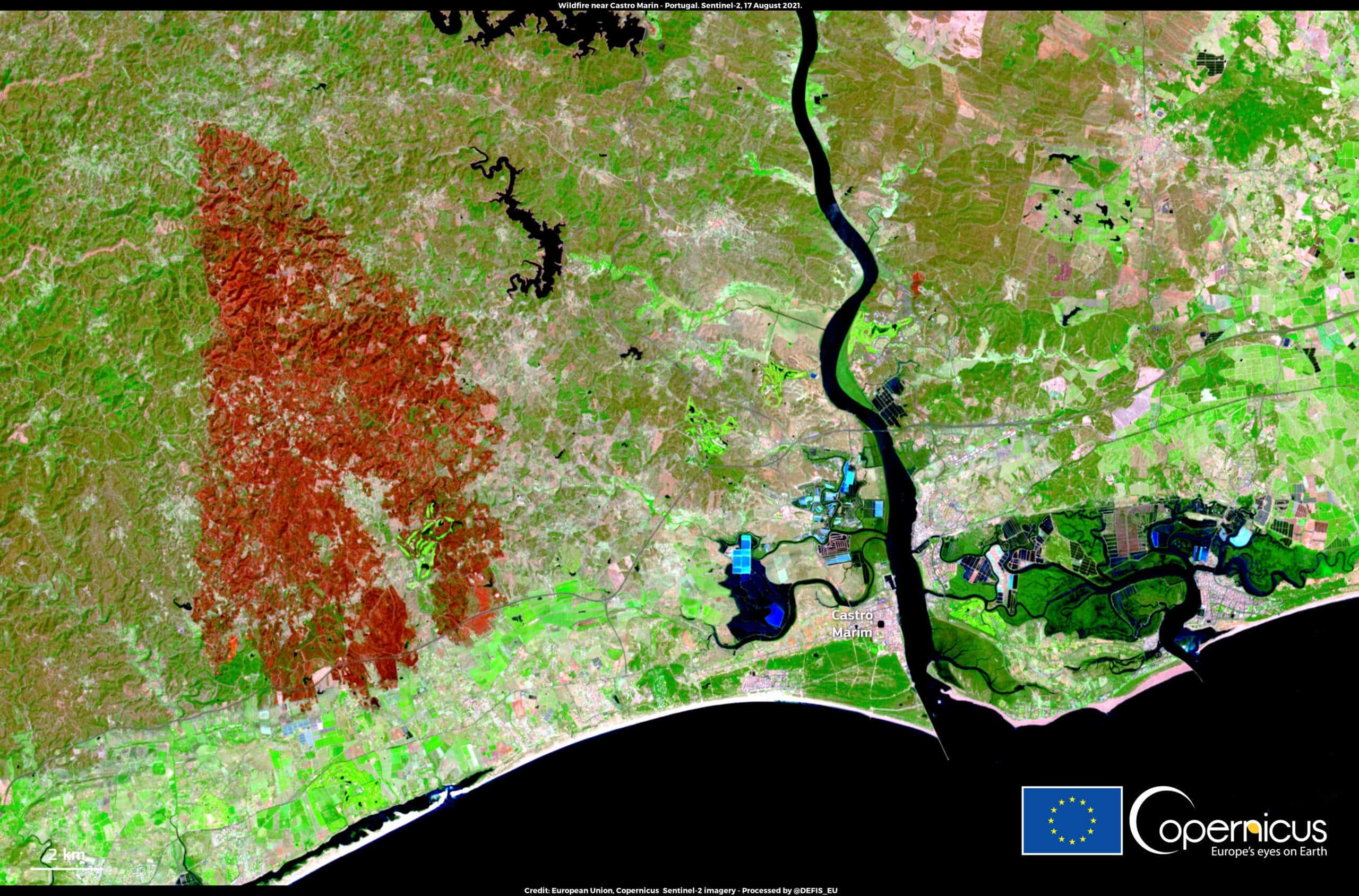
This image shows the massive burnt scar that resulted from wildfires in the Faro District, in southern Portugal. The wildfire is now under control, but it shows that Portugal is also vulnerable in the face of summer fires.


The bottom line: wildfires and global warming go hand in hand

The relationship between climate and fire is complex, but researchers are increasingly finding strong correlations between warm summer temperatures and large fire years. Since climate change is making heatwaves more likely, the logical conclusion is that fires will become more and more common (and more and more massive) as climate change starts to take its toll.

For instance, in the south-eastern US, models suggest that a warming of just one degree Celsius would increase the burned area by as much as 600% in some types of forests.

Of course, hotter weather doesn’t automatically bring wildfires — you also need ignition, and in many parts of the world, the majority of fires are started by humans. In the US, for instance, 84% of fires are started by humans

However, once a fire starts, hot weather can make the difference between an easily contained fire and a large-scale catastrophe — and this is pretty much what we’re seeing over the course of this summer.

Was this helpful?
Thanks for your feedback!
Related posts:
  1. Real extent of sea level rise obscured by 1991 massive volcano eruption
  2. Satellite images show rapid growth of glacial lakes around the world
  3. Satellite images detect massive gas leaks around the world
  4. The key to avoiding massive wildfires? Small, strategic controlled fires
  5. Beautiful map shows the mind-boggling extent of our underwater Internet cables
Tags: climate changesatellite imagerywildfire

ADVERTISEMENT
  • News
  • Environment
  • Health
  • Future
  • Space
  • Features
  • Reviews
  • More
  • About Us

© 2007-2021 ZME Science - Not exactly rocket science. All Rights Reserved.

No Result
View All Result
  • News
  • Environment
  • Health
  • Future
  • Space
  • Features
    • Natural Sciences
    • Health
    • History and Humanities
    • Space & Astronomy
    • Culture
    • Technology
    • Resources
  • Reviews
  • More
    • Agriculture
    • Anthropology
    • Biology
    • Chemistry
    • Electronics
    • Geology
    • History
    • Mathematics
    • Nanotechnology
    • Economics
    • Paleontology
    • Physics
    • Psychology
    • Robotics
  • About Us
    • About
    • The Team
    • Advertise
    • Contribute
    • Privacy Policy
    • Contact

© 2007-2021 ZME Science - Not exactly rocket science. All Rights Reserved.

Don’t you want to get smarter every day?

YES, sign me up!

Over 35,000 subscribers can’t be wrong. Don’t worry, we never spam. By signing up you agree to our privacy policy.

✕
ZME Science News

FREE
VIEW