ZME Science
No Result
View All Result
ZME Science
No Result
View All Result
ZME Science

Home → Environment

Tiny satellites reveal how urban trees respond to rising heat

Study reveals new insights into the compliate relationship between urban heat and seasonal vegetation leaf emergence.

Fermin KoopbyFermin Koop
July 3, 2023
in Environment, Environmental Issues
A A
Edited and reviewed by Tibi Puiu
Share on FacebookShare on TwitterSubmit to Reddit
Comparison of moderate resolution image with image using Cubesats technology. Image credits: Michael Alonzo.

Advancements in high-resolution imaging, facilitated by CubeSats—shoebox-sized devices deployed in low-Earth orbit—are enhancing scientists’ ability to obtain accurate measurements about trees’ response to a warming climate.

Using CubeSats imagery, Michael Alonzo, a researcher at American University, and his team looked at the role of heat in the early onset of the urban forest growing season. They found that heat may not accelerate season vegetation leaf emergence as previously thought. This is because previous studies used satellite images with poorer quality. A green pixel may be evidence of a growing canopy but perhaps something else entirely.

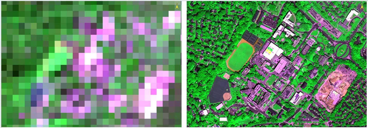
The images from cubesats are detailed enough to pick out individual trees, which offers much richer insight into vegetation growth across the planet.

“If we want to learn whether a given species or plant is changing its life cycle events due to warming, we need to do a better job zooming in on individuals and how they interact,” Alonzo said in a statement.

Urban heat and satellite technology

The urban heat island effect happens when impervious surfaces such as concrete and asphalt trap and radiate heat, causing city temperatures to be two or three degrees Celsius higher than in non-urban areas. Studying this phenomenon gives scientists a preview of how climate change may affect overall vegetation in non-urban areas.

Using satellite technology, previous studies have shown trees in cities green up earlier and lose leaves later compared with those in rural and natural areas. It’s like the seasons are shifting — and scientists have largely attributed this to heat. However, Alonzo’s new study is calling this into question.

“Heat plays a role but we may be overstating its importance,” he said in a statement.

Cities are packed with a mix and varied vegetation, from trees to shrubs to turfgrass. Pixelated images, the ones used so far, don’t allow scientists to study the species individually or to track changes on a daily basis. But that’s no longer a limitation with CubeSats, allowing scientists to see how leaves develop day after day, for example.

RelatedPosts

Surreal crooked trees shaped by Antarctic winds
NASA wants you to take photos of trees — to see how much carbon they can store
This 18-year-old Indian designed the world’s lightest satellite. NASA will launch it into space soon
Tree-planting campaign raises $8 million in five days

Alonzo and his team used CubeSats imagery for growing seasons from 2018 and 2020, covering over 10,000 tree crowns on streets in Washington DC. The sample included 29 species of broadleaf, leaf-shedding trees. The researchers pieced together the satellite images and monitored the timing of green up and leaf loss in the fall for every tree.

They then analyzed how much the length of a tree’s growing season could be attributed to its species and how much to its location. They also factored in how other factors such as air temperature and impervious surface cover influenced these timing. While the findings are just for Washington DC, they can apply to other urban and non-urban areas, Alonzo said.

Up next, the researchers highlighted the importance of further studying how species composition changes between urban and rural areas. This would allow scientists to improve their models of how trees and other vegetation respond to heat. Alonzo is now planning to work with researchers in Nigeria and Haiti to apply CubeSats imagery to monitor changes in agriculture and forests.

The study was published in the journal Science of the Total Environment.

Tags: satellitetrees

ShareTweetShare
Fermin Koop

Fermin Koop

Fermin Koop is a reporter from Buenos Aires, Argentina. He holds an MSc from Reading University (UK) on Environment and Development and is specialized in environment and climate change news.

Related Posts

Mapping vertical land motion across the New York City area, researchers found the land sinking (indicated in blue) by about 0.06 inches (1.6 millimeters) per year on average. They also detected modest uplift (shown in red) in Queens and Brooklyn. White dotted lines indicate county/borough borders. Credit: NASA/JPL-Caltech/Rutgers University.
Geology

Satellite data shows New York City is still sinking — and so are many big US cities

byFermin Koop
1 day ago
News

Astronomers Warn That Satellite Mega-Constellations Could Steal the Night Sky Forever

byMihai Andrei
3 weeks ago
Climate

White House Wants to Destroy NASA Satellites Tracking Climate Change and Plant Health

byMihai Andrei
1 month ago
Climate

Climate Change Unleashed a Hidden Wave That Triggered a Planetary Tremor

byMihai Andrei
3 months ago

Recent news

Meet the Bumpy Snailfish: An Adorable, Newly Discovered Deep Sea Species That Looks Like It Is Smiling

September 16, 2025

Scientists Just Found Arctic Algae That Can Move in Ice at –15°C

September 16, 2025

A 2,300-Year-Old Helmet from the Punic Wars Pulled From the Sea Tells the Story of the Battle That Made Rome an Empire

September 15, 2025
  • About
  • Advertise
  • Editorial Policy
  • Privacy Policy and Terms of Use
  • How we review products
  • Contact

© 2007-2025 ZME Science - Not exactly rocket science. All Rights Reserved.

No Result
View All Result
  • Science News
  • Environment
  • Health
  • Space
  • Future
  • Features
    • Natural Sciences
    • Physics
      • Matter and Energy
      • Quantum Mechanics
      • Thermodynamics
    • Chemistry
      • Periodic Table
      • Applied Chemistry
      • Materials
      • Physical Chemistry
    • Biology
      • Anatomy
      • Biochemistry
      • Ecology
      • Genetics
      • Microbiology
      • Plants and Fungi
    • Geology and Paleontology
      • Planet Earth
      • Earth Dynamics
      • Rocks and Minerals
      • Volcanoes
      • Dinosaurs
      • Fossils
    • Animals
      • Mammals
      • Birds
      • Fish
      • Amphibians
      • Reptiles
      • Invertebrates
      • Pets
      • Conservation
      • Animal facts
    • Climate and Weather
      • Climate change
      • Weather and atmosphere
    • Health
      • Drugs
      • Diseases and Conditions
      • Human Body
      • Mind and Brain
      • Food and Nutrition
      • Wellness
    • History and Humanities
      • Anthropology
      • Archaeology
      • History
      • Economics
      • People
      • Sociology
    • Space & Astronomy
      • The Solar System
      • Sun
      • The Moon
      • Planets
      • Asteroids, meteors & comets
      • Astronomy
      • Astrophysics
      • Cosmology
      • Exoplanets & Alien Life
      • Spaceflight and Exploration
    • Technology
      • Computer Science & IT
      • Engineering
      • Inventions
      • Sustainability
      • Renewable Energy
      • Green Living
    • Culture
    • Resources
  • Videos
  • Reviews
  • About Us
    • About
    • The Team
    • Advertise
    • Contribute
    • Editorial policy
    • Privacy Policy
    • Contact

© 2007-2025 ZME Science - Not exactly rocket science. All Rights Reserved.