The Caribbean and Florida should prepare for the worst, meteorologists say.
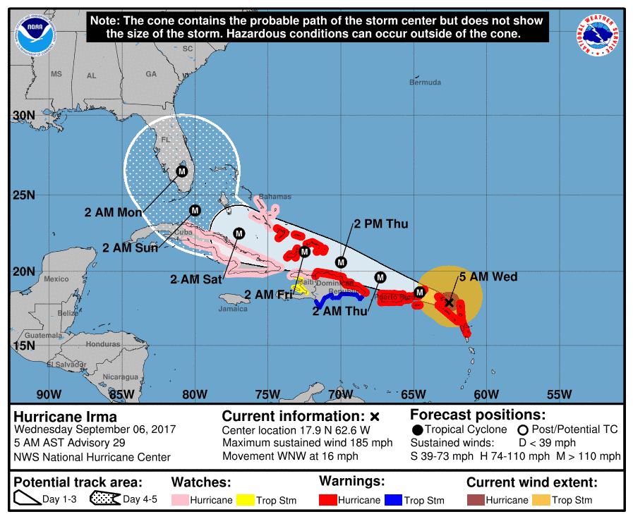
If you thought Harvey was bad, Irma promises to be even worse. The “extremely dangerous” Category 5 hurricane is already the strongest hurricane ever recorded outside the Caribbean and the Gulf of Mexico, with sustained winds of 185 miles per hour. The all-time record for a hurricane is 190 miles per hour.
Irma “will bring life-threatening wind, storm surge, and rainfall hazards to portions of the northeastern Leeward Islands tonight and tomorrow,” the National Hurricane Center reported Tuesday evening. “Preparations should be rushed to completion before the arrival of tropical-storm force winds tomorrow morning in Virgin Islands and Puerto Rico.”
The storm immediately threatens the small islands of the northern Leewards, including Antigua and Barbuda, as well as the British and U.S. Virgin Islands and Puerto Rico. Puerto Rico has not seen a storm of this magnitude for at least 100 years.
“The Leeward Islands are going to get destroyed,” warned Colorado State University meteorology professor Phil Klotzbach, a noted hurricane expert. “I just pray that this thing wobbles and misses them. This is a serious storm.”

Additionally, the hurricane is on course for the Dominican Republic, Haiti, Cuba and the southeastern Bahamas. Additionally, computer models indicate that the hurricane will almost certainly reach the Florida Keys, where it will encounter a fertile ground to brew an even bigger storm. The warm waters could accelerate the winds to over 220 mph, according to some models.
As a result, the entire state of Florida, especially South Florida, has been warned to take all possible precautions. It’s not known whether the hurricane will move on the eastern side of the state, on its western side, or go straight through it. But again, citizens are instructed to stockpile three days’ provisions and move out of Irma’s path, if possible. Mayor Carlos Gimenez said the voluntary evacuations could start as soon as Wednesday.
It’s still not clear exactly where Irma will go, but it’s definitely the kind of storm you don’t want to chance with — especially as the warnings grow more ominous.
“The chance of direct impacts from Irma later this week and this weekend is increasing in the Florida Keys and portions of the Florida Peninsula,” the hurricane center states. “However, it is too soon to specify the timing and magnitude of the impacts.”
Judging by the sheer size of the hurricane, it seems very likely that Florida will be at least partially hit.
Watch as Hurricane #Irma moves toward the Leeward Islands in this #GOES16 geocolor loop. Get the latest on Irma @ https://t.co/cSGOfrM0lG pic.twitter.com/ixIhkXqVNa
— NOAA Satellites (@NOAASatellites) September 5, 2017
“The hurricane force winds in Irma are wider than Florida,” tweeted Bryan Norcross, hurricane specialist at the Weather Channel. “You won’t need a direct hit to get Wilma-type winds & storm surge on both coasts.”
Elsewhere on Irma’s path, similar measures are urged.
“The decisions that we make in the next couple of hours can make the difference between life and death,” Puerto Rico Gov. Ricardo Rossello said. “This is an extremely dangerous storm.”
For a large hurricane, especially one of this size, the storm’s eyewall — the area around the relatively calm eye of the storm — is where the most damage tends to happen, and where the strongest winds tend to concentrate. But winds alone don’t make a strong hurricane. The storm surge and heavy rainfall also play a role, and a Category 5 hurricane hits all three on all aspects.
To keep an eye on Irma, you can follow:
- NOAA’s national hurricane center. Page updates every few hours.
- The Miami and Florida Keys National Weather Service branches. It’s Twitter, so it should update regularly.
- A Twitter feed of weather experts.
- Reputable news sources. Google News is a reliable aggregator.


