ZME Science
No Result
View All Result
ZME Science
No Result
View All Result
ZME Science

Home → Science

Mini-satellite shows the inside of Hurricane Dorian

The technology could bring a revolution in how we visualize storms.

Mihai AndreibyMihai Andrei
September 6, 2019
in Climate, News, Science
A A
Share on FacebookShare on TwitterSubmit to Reddit

RelatedPosts

US citizens see weather disasters worsening, according to new poll
Hurricane Dorian intensifies and heads towards the US
Hurricane Dorian hits the Bahamas as it approaches the United States
Hurricane Dorian devastates Bahamas, reaches Florida

A small NASA satellite offers important insight about the structure of the storm and its different layers.

Hurricane Dorian off the coast of Florida, as seen by the small satellite TEMPEST-D. Image credits: NASA.

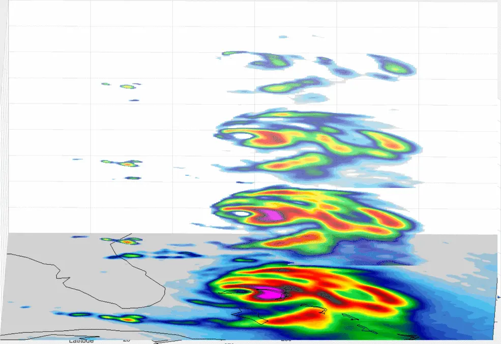
TEMPEST-D is no larger than a cereal box, and it’s inexpensive to boot — but its capability is remarkable. Above is a visualization of Hurricane Dorian, taken by TEMPEST-D at four depths (with four different radio wavelengths). The colors depict the heaviest rainfall inside the storm: pink and red are the most intense, whereas green and blue are the least intense. Essentially, the multiple vertical layers in the image above show where the strongest convective “storms” within the hurricane are moving into the atmosphere and can be used to study and predict the development of such storms.

After ravaging the Bahamas and causing unprecedented damage, Dorian seemed to dip in strength, but ramped back to a Category 3 hurricane as it struck the North and South Carolina coasts on Thursday. Its evolution came as a bit of a surprise, and the storm remains dangerous.

The unusual visualization can prove valuable exact in this sort of situation. The TEMPEST-D technology is essentially a radio wave instrument capable of measuring rain and moisture within the clouds with remarkable accuracy — on a low-cost, short development schedule. If it can track storms like Dorian (and early results suggest that it can), it could lead to a revolution in how we monitor such storms.

The complete TEMPEST-D spacecraft with the instrument integrated and ready for launch, shown with the solar panels deployed. Image credit: Blue Canyon Technologies.

By measuring the evolution of clouds from the moment of the onset of precipitation, a satellite constellation could reveal the ongoing cloud processes and help constrain the largest source of uncertainty in weather models (this could also be an important input larger-scale climate models).

A fleet of such satellites could be used to tracks storms all around the world, at a fraction of the cost of traditional satellites. This would improve our coverage of global storms, as well as generate more accurate forecasts.

Tags: dorianStorm Dorian

ShareTweetShare
Mihai Andrei

Mihai Andrei

Dr. Andrei Mihai is a geophysicist and founder of ZME Science. He has a Ph.D. in geophysics and archaeology and has completed courses from prestigious universities (with programs ranging from climate and astronomy to chemistry and geology). He is passionate about making research more accessible to everyone and communicating news and features to a broad audience.

Related Posts

Climate

US citizens see weather disasters worsening, according to new poll

byFermin Koop
6 years ago
Climate

Hurricane Dorian devastates Bahamas, reaches Florida

byFermin Koop
6 years ago
Climate

Hurricane Dorian hits the Bahamas as it approaches the United States

byFermin Koop
6 years ago
Climate

Hurricane Dorian intensifies and heads towards the US

byFermin Koop
6 years ago

Recent news

a hand over a burning scented candle

Why You Should Stop Using Scented Candles—For Good

July 31, 2025
different nuts in bowls at a market

People in Thailand were chewing psychoactive nuts 4,000 years ago. It’s in their teeth

July 31, 2025

To Fight Invasive Pythons in the Everglades Scientists Turned to Robot Rabbits

July 31, 2025
  • About
  • Advertise
  • Editorial Policy
  • Privacy Policy and Terms of Use
  • How we review products
  • Contact

© 2007-2025 ZME Science - Not exactly rocket science. All Rights Reserved.

No Result
View All Result
  • Science News
  • Environment
  • Health
  • Space
  • Future
  • Features
    • Natural Sciences
    • Physics
      • Matter and Energy
      • Quantum Mechanics
      • Thermodynamics
    • Chemistry
      • Periodic Table
      • Applied Chemistry
      • Materials
      • Physical Chemistry
    • Biology
      • Anatomy
      • Biochemistry
      • Ecology
      • Genetics
      • Microbiology
      • Plants and Fungi
    • Geology and Paleontology
      • Planet Earth
      • Earth Dynamics
      • Rocks and Minerals
      • Volcanoes
      • Dinosaurs
      • Fossils
    • Animals
      • Mammals
      • Birds
      • Fish
      • Amphibians
      • Reptiles
      • Invertebrates
      • Pets
      • Conservation
      • Animal facts
    • Climate and Weather
      • Climate change
      • Weather and atmosphere
    • Health
      • Drugs
      • Diseases and Conditions
      • Human Body
      • Mind and Brain
      • Food and Nutrition
      • Wellness
    • History and Humanities
      • Anthropology
      • Archaeology
      • History
      • Economics
      • People
      • Sociology
    • Space & Astronomy
      • The Solar System
      • Sun
      • The Moon
      • Planets
      • Asteroids, meteors & comets
      • Astronomy
      • Astrophysics
      • Cosmology
      • Exoplanets & Alien Life
      • Spaceflight and Exploration
    • Technology
      • Computer Science & IT
      • Engineering
      • Inventions
      • Sustainability
      • Renewable Energy
      • Green Living
    • Culture
    • Resources
  • Videos
  • Reviews
  • About Us
    • About
    • The Team
    • Advertise
    • Contribute
    • Editorial policy
    • Privacy Policy
    • Contact

© 2007-2025 ZME Science - Not exactly rocket science. All Rights Reserved.