ZME Science
No Result
View All Result
ZME Science
No Result
View All Result
ZME Science

Home → Other → Art

NASA offers dazzling 3D moon maps for artists and educators

It's the moon as you've never seen it before.

Mihai AndreibyMihai Andrei
October 7, 2019
in Art, Space
A A
Share on FacebookShare on TwitterSubmit to Reddit

A trove of lunar topographic data has been released by NASA free of charge, for anyone to access. The goal is to make visualizations more accessible to everyone, with as little effort as possible.

An illustration of how color and displacement maps are used in 3D animation software to paint and model an object like the Moon. Credits: NASA/Goddard/Scientific Visualization Studio

For Ernie Wright, producing stunning visualizations of the moon is just another day at the office. Wright is a science visualizer who works at the Scientific Visualization Studio at NASA’s Goddard Space Flight Center. His work is essentially to bring the Moon to life in unprecedented detail, using data from the Lunar Reconnaissance Orbiter (LRO).

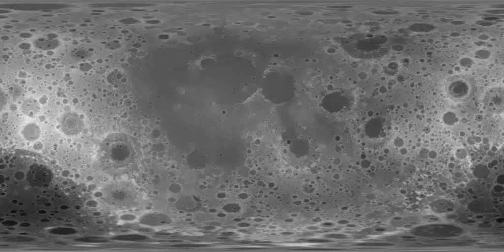
The LRO is a NASA robotic spacecraft currently orbiting the Moon. It boasts a detailed mapping program, offering a 3D map of the Moon’s surface at unprecedented 100-meter resolution (some areas, like the Apollo landing sites, feature much better resolution). This is vital not only for a better understanding of the moon itself but also to plan future landing and research missions on the moon — producing stunning maps is, of course, an excellent perk.

But Wright realized that many other people want to produce visualizations of the moon. Time after time, he was receiving inquiries about the data from artists. So he decided to share his creation as a way for artists to connect with the LRO mission. He released a stunning data pack with LRO data that can be freely accessed by anyone from this page on the NASA website.

“[The Moon kit] will bring the LRO data within reach of lots of other artists who want to do the kinds of things that I do,” Wright said.

This is one of the color maps available as 24-bit RGB TIFFs of various sizes. Credits: NASA/Goddard/Scientific Visualization Studio

In the age of smartphones, pretty much anyone can be a photographer. Even space photography has become more accessible. But having detailed visuals of the moon is still inaccessible to the world — unless you’re a leading space agency.

The LRO equipment essentially works as a scanner, going above the moon line by line, producing a grid, which is then used to generate a topographic image. The key is using a precisely timed laser beam, which is sent out from the spacecraft. When the laser hits the surface of the moon, it bounces back to the spacecraft, which measures how many nanoseconds it took for the laser to return — this being indicative of the topography in that specific place. If a beam comes back quicker, it has a higher elevation. The same technique is commonly used on Earth too.

The flat maps are then transposed into the almost-spherical shape of the moon for a full view of the satellite’s topographical features. These maps are already available as part of the the data publicly archived by the LRO instrument teams. All the data is presented in simple file formats, however, which are not supported by most computer graphics software. Releasing the data in an accessible, easy-to-use format will make it much more accessible to the world — especially as the data can now be used without extensive knowledge.

RelatedPosts

Satellite data shows New York City is sinking — and it’s not just because of the skyscrapers
Golden bat discovered in Bolivia
Researchers have just found the biggest galaxy ever discovered — and it’s big alright
The hand of blood: man makes sure no ocean water remains pristine

“All of this data is publicly available but not as accessible as it could be,” Wright said, “so, in releasing this in a form that a lot of people can appreciate and use.”

A displacement map centered on 0° longitude, is available at different resolutions.
Credits: NASA/Goddard/Scientific Visualization Studio

However, having access to these maps is just one step of the process, Wright says. The real challenge is in the storytelling built around them. It’s a lot like making a film Wright says.

“Using 3D animation software is a lot like filming live action, with lights, cameras, props and sets” Wright said, “but visualization is more like filming a documentary. You’re being factual, but you’re also creating a narrative.”

Since time immemorial, humans have looked up at the moon. As the first telescopes emerged, we also started building maps of the moon and a few decades ago, we even sent humans to the satellite. The good news is that now, we have maps of unprecedented quality, easily accessible at the tips of our fingertips. So if you have an idea for a project, make the most of it — it’s never been easier.

You can access the moon kit here.

ShareTweetShare
Mihai Andrei

Mihai Andrei

Dr. Andrei Mihai is a geophysicist and founder of ZME Science. He has a Ph.D. in geophysics and archaeology and has completed courses from prestigious universities (with programs ranging from climate and astronomy to chemistry and geology). He is passionate about making research more accessible to everyone and communicating news and features to a broad audience.

Related Posts

Animals

Dolphins and Whales Can Be Friends and Sometimes Hang Out Together

byMihai Andrei
33 minutes ago
Animals

Cats in a Finnish Village Have a Coat Pattern That’s Never Been Seen Before

byMihai Andrei
2 hours ago
Biology

Scientists Uncover 505-Million-Year-Old Penis Worm with a Mouthful of Bizarre Teeth

byMihai Andrei
3 hours ago
Anthropology

The Bishop, the Cleric, and the Woman on Seashells: Scientists Recreate the Faces of Scotland’s Early Christians

byMihai Andrei
4 hours ago

Recent news

Dolphins and Whales Can Be Friends and Sometimes Hang Out Together

August 20, 2025

Cats in a Finnish Village Have a Coat Pattern That’s Never Been Seen Before

August 20, 2025

Scientists Uncover 505-Million-Year-Old Penis Worm with a Mouthful of Bizarre Teeth

August 20, 2025
  • About
  • Advertise
  • Editorial Policy
  • Privacy Policy and Terms of Use
  • How we review products
  • Contact

© 2007-2025 ZME Science - Not exactly rocket science. All Rights Reserved.

No Result
View All Result
  • Science News
  • Environment
  • Health
  • Space
  • Future
  • Features
    • Natural Sciences
    • Physics
      • Matter and Energy
      • Quantum Mechanics
      • Thermodynamics
    • Chemistry
      • Periodic Table
      • Applied Chemistry
      • Materials
      • Physical Chemistry
    • Biology
      • Anatomy
      • Biochemistry
      • Ecology
      • Genetics
      • Microbiology
      • Plants and Fungi
    • Geology and Paleontology
      • Planet Earth
      • Earth Dynamics
      • Rocks and Minerals
      • Volcanoes
      • Dinosaurs
      • Fossils
    • Animals
      • Mammals
      • Birds
      • Fish
      • Amphibians
      • Reptiles
      • Invertebrates
      • Pets
      • Conservation
      • Animal facts
    • Climate and Weather
      • Climate change
      • Weather and atmosphere
    • Health
      • Drugs
      • Diseases and Conditions
      • Human Body
      • Mind and Brain
      • Food and Nutrition
      • Wellness
    • History and Humanities
      • Anthropology
      • Archaeology
      • History
      • Economics
      • People
      • Sociology
    • Space & Astronomy
      • The Solar System
      • Sun
      • The Moon
      • Planets
      • Asteroids, meteors & comets
      • Astronomy
      • Astrophysics
      • Cosmology
      • Exoplanets & Alien Life
      • Spaceflight and Exploration
    • Technology
      • Computer Science & IT
      • Engineering
      • Inventions
      • Sustainability
      • Renewable Energy
      • Green Living
    • Culture
    • Resources
  • Videos
  • Reviews
  • About Us
    • About
    • The Team
    • Advertise
    • Contribute
    • Editorial policy
    • Privacy Policy
    • Contact

© 2007-2025 ZME Science - Not exactly rocket science. All Rights Reserved.