A geological fault is (in geology) a planar fracture or discontinuity in a volume of rock, across which there has been significant displacement along the fractures. More simply put, it’s a fracture in the Earth’s crust where blocks of rock have moved relative to each other due to tectonic forces.
Geological faults can be as small as a coin or kilometers long; they can come isolated or in a system of faults; and they can be subtle or very, very obvious. They are key geological features that have been studied for over a century.
Geological faults and tectonics

The main process behind geological faults is plate tectonics, which describes the large-scale movement of seven major and many minor plates that make up Earth’s lithosphere. The Earth’s crust is not a single, unbroken shell but is instead divided into rigid plates that “float” atop the semi-fluid asthenosphere beneath them. The interactions between these plates are responsible for the majority of the planet’s seismic and volcanic activity, as well as the creation of mountains and ocean basins.
Faults are formed as a direct result of these interactions.

Essentially, when tectonic plates move, they create stress and pressure. They can either converge, diverge, or slide past one another, accumulating stress that builds up more and more. When the stress becomes too great, the rocks on either side of a fault suddenly shift, creating a geological fault.
This process releases energy, and if the fault is big enough, it can also trigger earthquakes. Regardless, however, this buildup of stress and this movement creates a fault—a fracture or zone of fractures between two blocks of rock, which allows them to move relative to each other.

Types of Faults: The Diversity of Earth’s Cracks
Remember when we said faults can come in all sorts of shapes and sizes? Well, because the movement of tectonic plates is so complex, it can create multiple types of faults. This is important for geologists for two reasons. First of all, it enables a better understanding of the area and how it develops. Secondly, it’s useful for predicting earthquakes and mapping out potential hazards.

1. Normal Faults
Normal faults occur in regions where the Earth’s crust is being pulled apart by extensional forces. This stretching causes one block of the crust to slip downward relative to the other. These faults are common in areas where tectonic plates are diverging, such as along mid-ocean ridges where new oceanic crust is being created.
A prime example of normal faulting can be found in the East African Rift, a region where the African continent is slowly being pulled apart. The rift is a zone of active faulting and volcanic activity, which will eventually lead to the formation of a new ocean basin as the continent continues to split.
2. Reverse Faults (Thrust Faults)
Reverse faults, also known as thrust faults, occur in regions where the Earth’s crust is being compressed. In these faults, one block of crust is pushed upward relative to the other. These faults are often found in collision zones where tectonic plates are converging, such as along the edges of mountain ranges.
The Himalayas, the world’s highest mountain range, is a classic example of reverse faulting. The collision between the Indian Plate and the Eurasian Plate has forced the crust upward, creating towering peaks like Mount Everest. This process is ongoing, which means that the Himalayas continue to rise as the two plates continue to converge.
3. Strike-Slip Faults
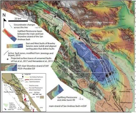
Strike-slip faults occur where tectonic plates slide past each other horizontally. These faults are characterized by lateral movement, meaning that the blocks of crust move sideways relative to one another. The most famous example of a strike-slip fault is the San Andreas Fault in California.
The San Andreas Fault is a boundary between the Pacific Plate and the North American Plate. As these two plates slide past each other, they cause frequent and sometimes devastating earthquakes, such as the 1906 San Francisco earthquake. The lateral motion of strike-slip faults can be particularly destructive in urban areas built across or near the fault line.
4. Oblique-Slip Faults
Oblique-slip faults are a combination of the movements found in normal, reverse, and strike-slip faults. These faults occur when there is both vertical and horizontal movement along the fault plane. Oblique-slip faults are less common but can occur in complex tectonic settings where multiple forces are acting on the crust simultaneously.
How geologists study faults

We’ve mentioned that faults have been studied for hundreds of years. Faults have been one of the core clues for our current understanding of global plate tectonics, and they remain important features that are studied in a variety of ways.
1. Direct measurements
Geologists measure faults using a variety of techniques to understand their geometry and movement. This is the most standard and “old school” way of studying faults. They typically assess the fault’s strike, which is the direction of the fault line relative to the Earth’s surface, and the dip, which is the angle at which the fault plane inclines from the horizontal. The rake (or slip) angle is also measured, which indicates the direction of the movement along the fault plane.
Additionally, geologists use tools like GPS and laser rangefinders to measure the amount of displacement or slip along the fault, which is the distance that the rocks have moved past each other. By combining these measurements, geologists can model the fault’s behavior, assess potential seismic activity, and better understand the dynamics of tectonic forces.
2. Seismic Monitoring
One of the primary tools for studying faults and predicting earthquakes is seismic monitoring. Some faults are active, some are not — and the active ones can create earthquakes. Networks of seismometers around the world constantly record the vibrations of the Earth, allowing scientists to detect and analyze fault activity in real-time. By studying the patterns of small tremors, or “foreshocks,” researchers can sometimes identify areas where stress is building up along a fault.
However, predicting the exact timing of a major earthquake remains an ongoing challenge. While foreshocks can provide some warning, not all earthquakes are preceded by such events, and the time between foreshocks and a major quake can vary widely.
2. Geodetic Techniques
Geodetic techniques, such as GPS and satellite-based radar, allow scientists to measure the slow, creeping movements of the Earth’s crust over time. By monitoring these movements, researchers can identify areas where stress is accumulating and estimate the potential for future earthquakes.
For example, by studying the gradual movement of the San Andreas Fault, scientists have identified certain “locked” sections of the fault where stress is building up and where a major earthquake could occur in the future. However, while these techniques can provide valuable insights, they cannot pinpoint the exact timing of an earthquake.
3. Earthquake Early Warning Systems
In recent years, advances in technology have led to the development of earthquake early warning systems. These systems use a network of sensors to detect the initial, less destructive waves of an earthquake (P-waves) and send out warnings before the more destructive waves (S-waves) arrive. While the warning time may only be a matter of seconds to minutes, it can be enough to take cover, stop trains, shut down power plants, and save lives.
Japan, Mexico, and California are among the regions that have implemented such systems, and while they are not foolproof, they represent a significant step forward in mitigating the impact of earthquakes.
We all have our faults
Geological faults are a testament to the dynamic forces that shape our planet. Without plate tectonics, we wouldn’t have life on this planet, and faults are a consequence of the same forces.
While they can cause destruction, they also play a vital role in shaping the Earth’s surface, creating mountains, and driving the processes that make our planet habitable. Understanding and studying these faults is crucial for understanding the Earth’s geology, mitigating risks, and preparing for the future.
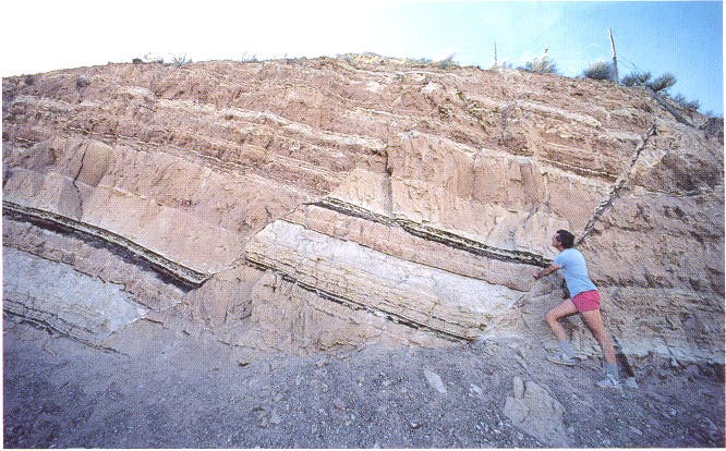
If you want to look at geological faults in your area, look for local maps that include faults — most areas have detailed such maps. However, in order to truly be able to see a fault, it needs to be exposed (not covered by vegetation or anything else). Be careful when exploring such areas; never take any risks as some faults are inherently surrounded by unstable rocks.


