Radar satellites could show areas where sinkholes are forming, predicting the collapse before it happens
The eye in the sky could help us figure out what's happening on the ground.
Sinkholes often appear suddenly, without warning. A new tool could help change all that, by looking for tiny soil shifts from high above.
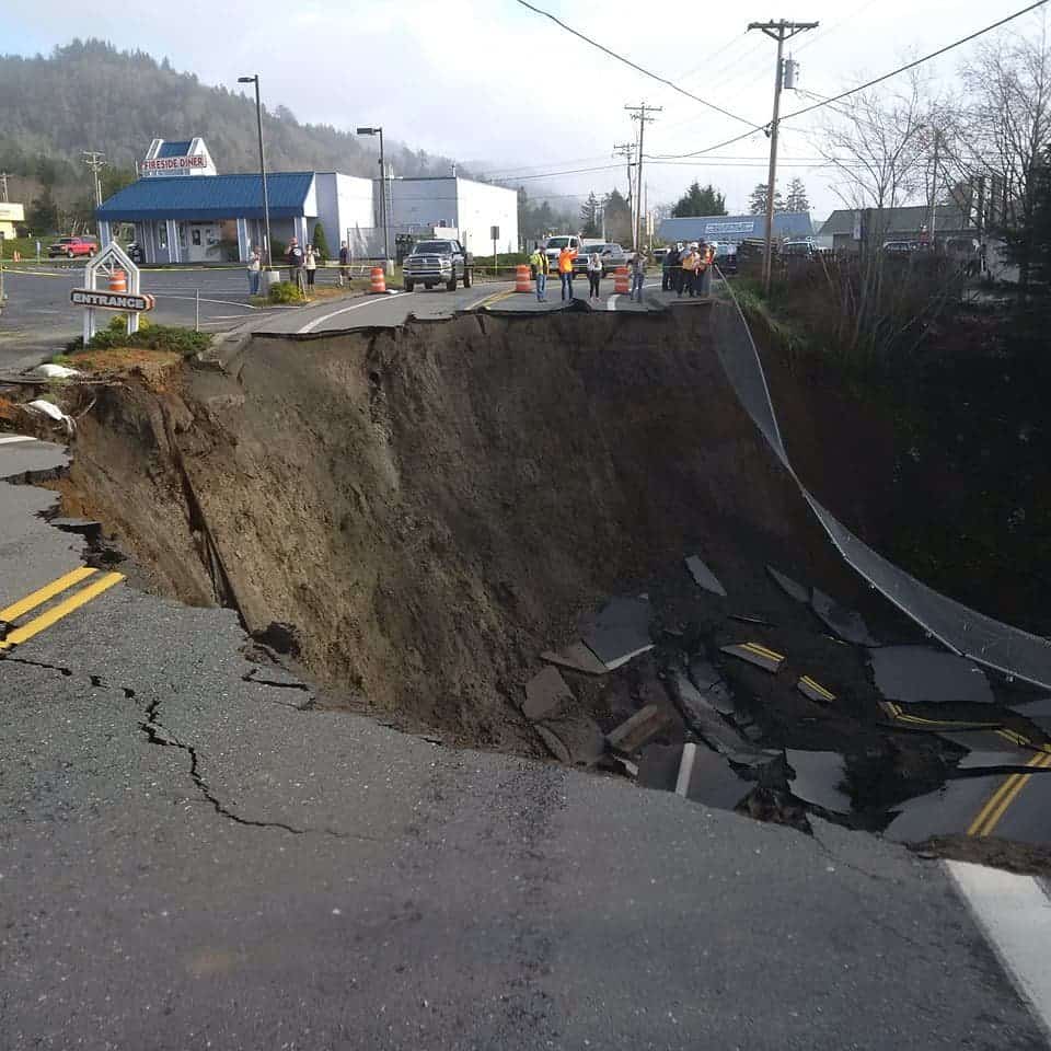
Sinkholes are holes in the ground that form in limestone (or other limestone-like) rocks beneath the soil. Basically, acidic water enters the subsurface and starts dissolving the rocks. The problem is that although sinkholes form and evolve slowly, you often don’t see a sinkhole coming, because it dissolves from the inside. This unpredictability makes them very problematic, but there could be a solution: airborne monitoring.
Geophysics professor Shimon Wdowinski and his former postdoctoral research fellow Talib Oliver-Cabrera from Florida University teamed up with researchers from the University of South Florida to inspect several areas across Florida’s “Sinkhole Alley”.
The area is rich in limestone and dolomite rocks, both of which can be dissolved with relative ease by water. But on the ground, signs of sinkhole formation can be tough to spot. You could look for things like cracks in buildings or windows or windows not closing properly due to ground subsidence (a phenomenon that typically precedes sinkhole formation) — but overall, the odds of detecting a sinkhole are against you.
But if you use satellite data, that may change. The Florida researchers used radar technology to detect changes in land and monitor subsidence. They used satellites equipped with InSAR (Interferometric Synthetic Aperture Radar), which can detect ground changes with millimeter-level accuracy..
“Our research shows that with special radar satellite technology, we can monitor large areas for localized subsidence and provide highly valuable warning information that could protect people and their property,” Wdowinski said.
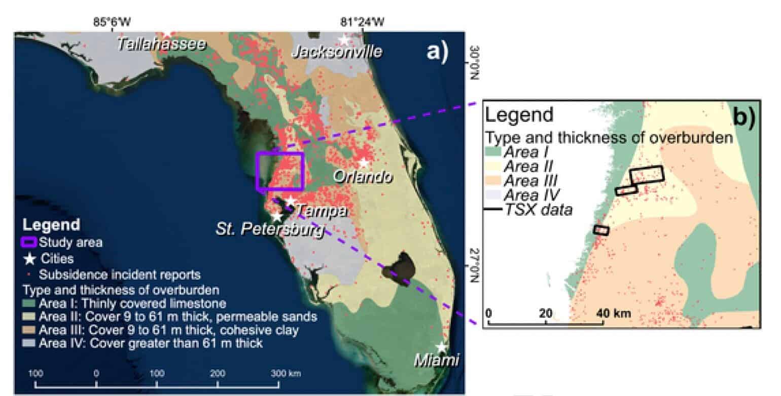
The approach proved successful, and numerous sinkhole areas were identified. From there, researchers went on to ground-truth their findings. They focused on sites that seemed particularly at risk — in some areas, land subsidence was happening at a rate of over half a centimeter per year.
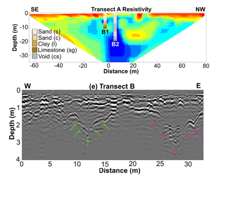
To test whether sinkholes were indeed responsible for the observed subsidence, the researchers used ground-based geophysical methods. The dissolved area has different physical properties compared to the surrounding subsurface. In this case, researchers deployed surveys using electrical methods and another type of radar (ground-penetrating radar), as well as boreholes to dig into the suspected sinkholes. The results confirmed that sinkholes were indeed responsible for the observed subsidence.
The method proved to be effective, researchers say, and it could be deployed anywhere such satellite data exists.
“While we tested the method only in Hernando and Pasco counties, it would also work in Hillsborough and Pinellas Counties, and anywhere else with similar construction and vegetation patterns,” said Sarah Kruse from the University of South Florida.
However, there are some caveats to the study. For starters, it’s not clear what size of sinkholes can be detected; smaller, incipient ones may evade detection. In addition, sinkholes sometimes evolve quite quickly, before the satellite would be given a chance to detect it.
“Overall, InSAR implementation for detecting sinkhole activity in West-Central Florida has shown to be a promising tool, but still with limitations,” the researchers write in the study. “Sinkhole collapse can happen in a matter of seconds. Thus, the technique detection capability is limited to sinkholes that present subsidence for at least more time than the repeat pass interval of the satellite.”
Still, given the damage that sinkholes can do, the method could be very helpful even in these shortcomings. Areas prone to sinkholes could be monitored closely and a lot of damage could be prevented.
The study was published in the journal Remote Sensing of Environment.