NASA Radar demonstrates ability to foresee sinkholes
New analyses of NASA airborne radar data collected in 2012 reveal the radar detected indications of a huge sinkhole before it collapsed and forced evacuations near Bayou Corne, La. that year. Researchers believe that they can use this type of data, usually routine gathered, to foresee at least some of the sinkholes. I’ve written a […]
New analyses of NASA airborne radar data collected in 2012 reveal the radar detected indications of a huge sinkhole before it collapsed and forced evacuations near Bayou Corne, La. that year. Researchers believe that they can use this type of data, usually routine gathered, to foresee at least some of the sinkholes.
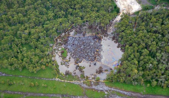
The sinkhole at Bayou Corne, Louisiana.
I’ve written a comprehensive article about sinkholes (what they are, how they form, and how you can stay safe) which I really recommend you read if you live in a sinkhole-threatened area, or if this is of interest to you. If you don’t want to read it however, I’ll sum it up for you: sinkholes are are natural depressions (or holes) in the surface of the Earth’s surface, (usually) caused by karst processes. Karst processes occur when the bedrocks are soluble – in other words, in 99% of all cases, in carbonate rocks (like limestone or dolomite) or evaporitic rocks (like gypsum or anhydrite). They usually form without apparent warning, and can be extremely dangerous.
NASA collected their data as part of an ongoing campaign to monitor sinking of the ground along the Louisiana Gulf Coast. Researchers Cathleen Jones and Ron Blom of NASA’s Jet Propulsion Laboratory (JPL) in Pasadena, California, analyzed interferometric synthetic aperture radar (InSAR) imagery of the area acquired during flights of the agency’s Uninhabited Airborne Vehicle Synthetic Aperture Radar (UAVSAR). InSAR is a radar technique used in geodesy and remote sensing, detecting and measuring very subtle deformations in Earth’s surface.

Analyses by NASA’s UAVSAR after the Bayou Corne, La., sinkhole formed show it detected precursory ground movement of up to 10.2 inches (260 millimeters) more than a month before the sinkhole collapsed. Colors represent surface displacement (one full color wrap equals 4.7 inches (120 millimeters).
Image Credit: NASA/JPL-Caltech
Their analysis showed the ground surface layer deformed significantly at least a month before the collapse moving mostly horizontally up to 10.2 inches (260 millimeters) toward where the sinkhole would later form. This may not seem like much, but the ground surface doesn’t just move a quarter of a meter for no reason – and the deformations were observed over a much larger area than the actual sinkhole – about 1,640 by 1,640 feet, (500 by 500 meters). The sinkhole measured about 10×0 meters.
The results of this study are published in the journal Geology.
“While horizontal surface deformations had not previously been considered a signature of sinkholes, the new study shows they can precede sinkhole formation well in advance,” said Jones. “This kind of movement may be more common than previously thought, particularly in areas with loose soil near the surface.”
The problem with sinkholes is that they hit hard – and fast. The Bayou Corne sinkhole formed on Aug. 3, 2012, after weeks of minor earthquakes and bubbling natural gas that provoked community concern. It was clear that something’s going on, but it’s hard to estimate just how urgent the situation really is.
“Our work shows radar remote sensing could offer a monitoring technique for identifying at least some sinkholes before their surface collapse, and could be of particular use to the petroleum industry for monitoring operations in salt domes,” said Blom. Salt domes are dome-shaped structures in sedimentary rocks that form where large masses of salt are forced upward. By measuring strain on Earth’s surface, this capability can reduce risks and provide quantitative information that can be used to predict a sinkhole’s size and growth rate.”
The good thing is that at least in the US, NASA gathers this type of information relatively frequently – and not only do they gather it, but they also share this unique knowledge with the global community, working with institutions in the United States and around the world, so hopefully, we’ll be getting a “heads up” when it comes to sinkholes.


