New Google platform provides near-real-time data on land change and natural disasters
Fires, floods, and human intervention such as deforestation will soon be visible directly on the platform.

Having access to real-time, unrestricted mapping has had a massive impact on our day-to-day lives. Most of us use some version of these maps to navigate our surroundings or see where different things are, but that’s just the tip of the iceberg when it comes to what you can do with this data.
More recently, Google started expanding the capability of its Google Maps and Google Earth platforms by offering various functions, including a time-lapse tool that enables users to see what parts of the world were like in the past and how they’ve changed in recent decades.
This time, the tech giant took things even further. In partnership with the World Resources Institute (WRI), a global non-profit research institute, Google will use its Earth engine to make other types of data more readily available. Specifically, the engine will take images from the Copernicus Sentinel-2, an environmental observation satellite, and areas based on their coverage, processing them in an easily viewable fashion.
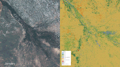
Basically, land area will be classified based on its coverage and split into one of the following categories: water, flooded vegetation, built-up areas, trees, crops, bare ground, grass, shrub/scrub, or snow/ice. The goal is to offer useful data for environmental monitoring and other related activities, enabling scientists, policymakers, and any other stakeholders to monitor land ecosystems and make better plans to protect our planet.
“The global land squeeze pressures us to find smarter, efficient, and more sustainable ways to use land. If the world is to produce what is needed from land, protect the nature that remains and restore some of what has been lost, we need trusted, near real-time monitoring of every hectare of the planet,” saus Craig Hanson, Vice President of Food, Forests, Water and the Ocean at WRI.
This is not exactly a new idea, but existing services typically provide data on a weekly, monthly, or even annual basis. Google’s Dynamic Services will work with data as recent as two days old. Making the data open and easily accessible, even to those without programming or mapping experience, is also a useful step toward making this type of important data available to the world.
“We’re excited to put this open, freely available dataset and the methodology behind it into the hands of scientists, researchers, governments and companies. Together, we can make wiser decisions to protect, manage and restore our forests, nature and ecosystems,” a Google announcement reads.
You can access the platform here. Another version can be accessed at Resource Watch. A peer-reviewed paper was also published in the journal Nature Scientific Data.


