A new tropical storm, Peter, has formed in the Atlantic. Another, Rose, is likely to follow soon
It's been a busy year for hurricanes.
A new tropical storm has been brewing in the Atlantic. Christened “Peter”, it marks the 16th named storm of this year’s hurricane season.
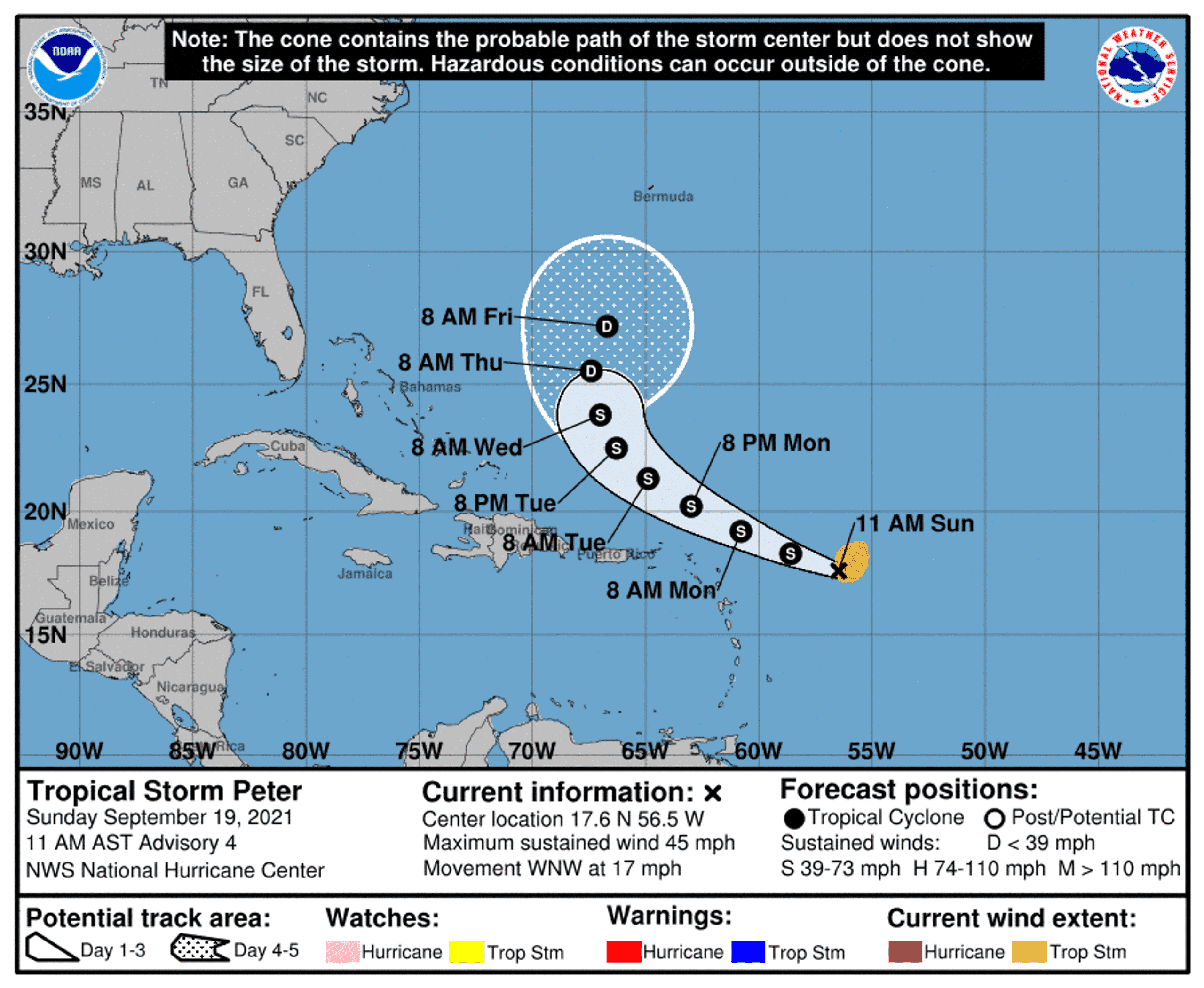
Tropical storm Peter formed east of the Caribbean on Sunday, centered some 400 miles off the Leeward Islands. According to the National Hurricane Center (NHC), the storm is expected to pass north of the Lesser Antilles and is likely to produce between one and three inches of rainfall around its edge. Puerto Rico, the Virgin Islands, and the Leeward Islands are liable to see “areas of urban and small stream flooding” up through Tuesday, the NHC adds. Top wind speeds are expected to fall below or around 45 mph (72.5 km/h).
Stormy again
Although it has barely been a week since Hurricane Nicholas slid across Texas and Louisiana, and just a little over three since Hurricane Ida battered the same shores, a new storm is brewing in the Atlantic.
Tropical storm Peter is the sixth hurricane to form this year. Along with these, three major hurricanes (meaning they were a category 3 or higher in intensity) have raged in 2021, making it quite the busy year. Naturally, more could be on the way. As far as Peter is concerned, the NHC notes that a strong cold mass of air is moving eastward across the U.S., which is likely to butt heads with the storm. This front of cold air should push Peter back out to the ocean and insulate the Eastern Seaboard, if not completely, then at least to a certain extent.
Despite the formation of this tropical storm, no coastal watches or warnings were in effect as of this Sunday in any of the areas highlighted by the NHC.
Forecasters are also keeping tabs on a tropical depression in the eastern Atlantic. This particular low-pressure system was picked up around 315 miles west-southwest of the Cabo Verde Islands (off the western coast of Africa). While not particularly intense right now, moving northwards at around 14 mph with sustained winds of around 35 mph (22.5 and 56.3 km/h respectively), there is still a high chance that it will morph into a new tropical storm — which will be named “Rose”. The two storms started coalescing pretty much at the same time, but Peter developed more rapidly in intensity.
If we consider Rose as well, this would be the third Atlantic hurricane season in recorded history to have 17 named storms by the 20th of September. The others were the 1966 season, the 2005 one, and 2020. The link between climate change and freak weather or events such as hurricanes has been highlighted in the past, and the high incidence of storms recorded this season certainly seems to follow that hypothesis.
Each hurricane in every year is given a name starting with the corresponding letter of the alphabet — A for the first, B for the second, and so on. Last year, in particular, had so many named storms that meteorologists exhausted the alphabet and had to assign Greek letters, only the second time in history that this has happened. It still holds the record for the highest number of storms in a single year, 30. The runner-up is still the 2005 hurricane season, with 28 recorded storms.
Hurricanes are primarily fed by expanses of open, warm water. As the planet’s climate heats up overall, so do the oceans, meaning we’re likely to see stronger and more frequent events of this kind in the future. They are also likely to become wetter — to carry more precipitation — due to higher overall levels of moisture in the atmosphere, as higher mean temperatures lead to higher levels of surface evaporation. As storms increase in intensity and sea levels rise, they are also liable to generate more storm surges, and thus become more dangerous over time.
A report by the United Nations released in August has also issued a warning to this extent. According to the document, unavoidable shifts in climate will lead to more intense and more frequent heatwaves and droughts over the next 30 years. Hurricanes have already been following this trend for the last 40 years, it adds.