Map compiled by NASA shows how lightning strikes the Earth
By the time you've finished reading this sentence, thousands of lightning bolts had already discharged enormous amounts of energy onto Earth's surface. Now, a map compiled by NASA using two decades worth of measurements shows which places are hit most often. For instance, land is hit more frequently than the ocean, as is the equatorial region compared to other regions of the globe.
By the time you’ve finished reading this sentence, thousands of lightning bolts have already discharged enormous amounts of energy onto Earth’s surface. Now, a map compiled by NASA using two decades worth of measurements shows which places are hit most often. For instance, land is hit more frequently than the ocean, as is the equatorial region compared to other regions of the globe.
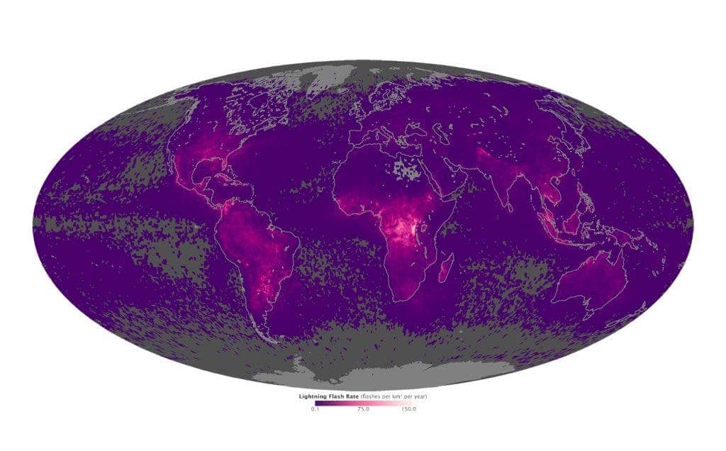
Image: NASA
Lightning is a giant discharge of electricity accompanied by a brilliant flash of light and a loud crack of thunder. The spark can reach over five miles (eight kilometers) in length, raise the temperature of the air by as much as 50,000 degrees Fahrenheit (27,700 degrees Celsius), and contain a hundred million electrical volts. Like all of nature’s powerful mechanisms, lightning may actually be the ultimate life bringer, thought it may sometimes cause fatalities. The immense heat and other energy given off during a stroke has been found to convert elements into compounds that are found in organisms, so during the planet’s primal period lightning may have helped spur life – like a defibrillator.
The following map was made by researchers at NASA taking note of data taken by the Lightning Imaging Sensor (LIS) on NASA’s Tropical Rainfall Measuring Mission satellite between 1998 and 2013 and the Optical Transient Detector (OTD) on the OrbView-1/Microlab satellite between 1995 and 2000. A researcher explains how the instrument works:
“It’s taking very rapid updates,” said Daniel Cecil, a member of the Global Hydrology and Climate Center’s lightning team. “So it will measure a background scene, and then with very rapid updates check to see if there’s a sudden change in brightness from that background scene.” If there is, the instrument records that as a flash of lightning.
In the map, areas with the fewest lightning strikes are gray and purple, while those with the highest number are in pink. We can immediately distinguish that land gets much more pounded by lightning than the ocean. That’s because land absorbs heat much faster from sunlight, causing stronger convection and higher atmospheric instability, which ultimately causes lightning storms.
Westward on the map, lightning flashes run down Mexico and Central America, before reaching their peak in Colombia and Venezuela; eastward, they peak in Singapore and Malaysia. But the fiercest lightning storms can be found, by far, in Congo. Also, lightning is far more likely to occur near the equator. Roughly 90 percent of the lightning strikes on Earth occur between the 38th parallel south and 38th parallel north latitudes, said Cecil.
Maps, satellite imagery and more such data is essential to expanding our view of how the climate really works, and consequently help build better models that reflect reality. Soon, NASA plans on mounting lightning imaging sensor to the International Space Station from where it will be continuously able to track certain spots on the planet for storms.
“Right now, we’re piecing together snapshots,” Cecil said. “As a satellite goes over, we get to look at a storm for about a minute and a half. And in this next generation a few years from now, we’re going to have continuous measurements. So as a storm pops up, we’re going to see its entire life cycle from the first flash to the last.”


