Landsat satellite spots sunken shipwrecks in coastal waters
An estimated 3 million shipwrecks are scattered across the planet’s oceans.
An estimated 3 million shipwrecks are scattered across the planet’s oceans. Most of them take place close to the shore, falling victim to storms, rocks, reefs, and so on. Identifying such shipwrecks is not only important from an archaeological and historic perspective, nor is it done only for finding treasure. These ships can have a major environmental effect: they can create a reef, but can also leak onboard fuel and corroded heavy metals. Nearshore shipwrecks are also a shipwreck hazard themselves.
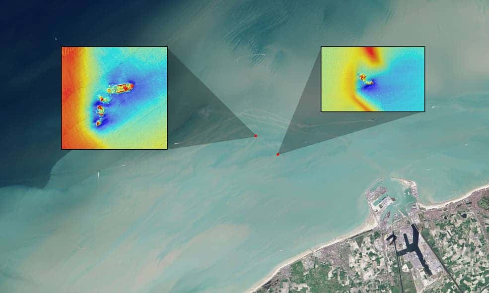
In this natural color Landsat OLI image, long sediment plumes extend from the wreck sites of the SS Sansip and SS Samvurn. Insets show elevation models (created by a multibeam echosounder) of the wrecks on the seafloor.
Credits: NASA/USGS Landsat/Jesse Allen/NASA Earth Observatory/Matthias Baeye et al
However, finding shipwrecks can be quite challenging and requires data which can be expensive and time-consuming to acquire, so researchers tried to go for another approach. They tried looking for the sediment plumes created by the ships as they sink to the bottom of the ocean, using open-source data from the NASA/USGS Landsat 8 satellite. The Landsat program is the longest running enterprise for acquisition of satellite imagery of Earth, being launched in 1972.
A new study published in the Journal of Archaeological Science, led by authors Matthias Baeye and Michael Fettweis, from the Royal Belgian Institute of Natural Sciences, describes a new way to discover these ships. Their study, conducted in a coastal area off of the Belgium port of Zeebrugge, relied on a detailed multibeam echosounder survey of wreck sites, previously conducted by the Flemish government and now freely available. The coast of Belgium, as well as the ones from Netherlands, France and England are riddled with shipwrecks, mostly from World War II (but not only). Most of the time, the ships are stuck in laden-rich waters with slow or absent currents.
The study looked at shipwrecks in waters as deep as 15 m (50 feet). This kind of study would only work in shallow waters, because deeper waters would block visual sight. The researchers started with the known location of four fully submerged shipwrecks, mapping the plume they created as they sank in the sediments. They found a pattern for these ships, and propose that the same methodology could be done in reverse – starting from the sediment plumes and identifying shipwrecks.
So far, their approach worked fine for test sites, but now they have to properly test it and start looking for unknown shipwrecks. Given that coastal waters are typically shallow, often sediment-laden, and where most shipwrecks occur, this new shipwreck detection method could prove useful for marine archaeologists as well as for environmentalists.


