New maps reveal the lost continent of Zealandia in amazing detail
Researches mapped the tectonic profile and the bathymetry of the continent
About 3,500 feet (1,000 meters) below the Pacific Ocean, off the coast of Australia, there lies Zealandia, the lost eight continent that has long fascinated scientists since it was identified in 2017.
Now, researchers from New Zealand were able to map the submerged landmass in impressive detail, offering a more accurate image of the submerged continent than we’ve ever seen.
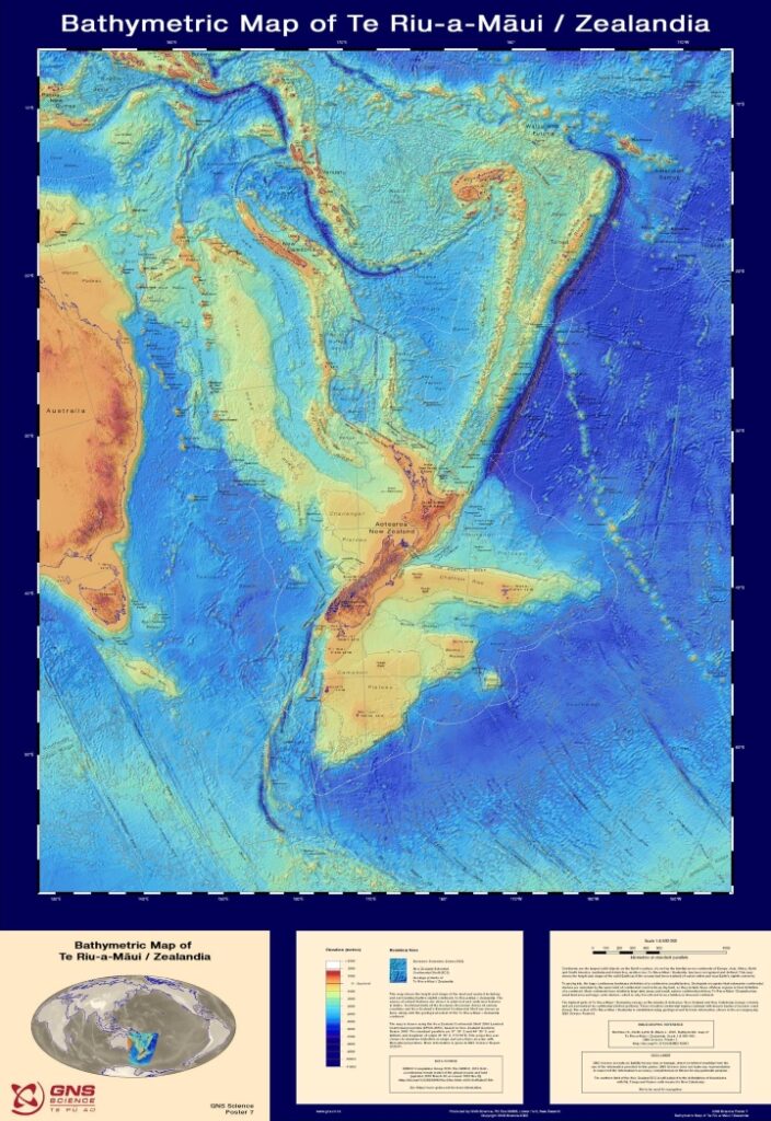
The researchers from GNS Science mapped the shape and size of the continent in unprecedented detail, making the maps available to everyone on an interactive website. They mapped the bathymetry surrounding Zealandia, the shape and depth of the ocean floor, as well as its tectonic profile, illustrating where the continent falls across the limits of tectonic plates.
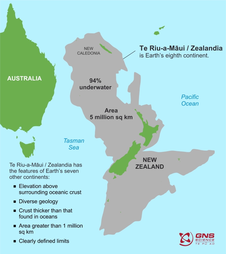
The maps revealed brand new information on how Zealandia formed before it became submerged underwater millions of years ago. The area is has a surface of some two million square miles (five million square kilometers), which is half the size of Australia. But only 6% of it is above sea level, which underpins the north of New Zealand, and the rest is underwater.
“We’ve made these maps to provide an accurate, complete and up-to-date picture of the geology of the New Zealand and southwest Pacific area – better than we have had before,” lead author of the maps, geologist Nick Mortimer, said in a statement. “Their value is that they provide a fresh context in which to explain and understand the setting of New Zealand’s volcanoes, plate boundary and sedimentary basins.”
Mortimer and his team mapped both Zealandia and the submerged continent to raise awareness about it, but also to better understand the continent. The bathymetric map (below) shows how high the continent’s mountains and ridge rise toward the water’s surface. It also shows coastlines, territorial limits, and the names of major undersea features. The map is part of an initiative to map all the ocean floor of the planet by 2030.
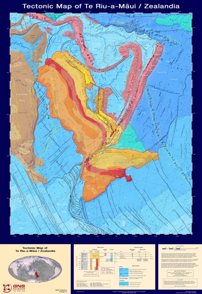
A second map done by the team (below) shows the types of crust that make up Zealandia, the age of the crust, and the major faults. The continental crust, which is Earth’s older and thickest crust, can be seen in the map in red, orange, yellow, and brown. Meanwhile, the oceanic crust can be seen in blue. The volcanoes are illustrated with red triangles.
A recently discovered continent
Geophysicist Bruce Luyendyk came up with the moniker Zealandia in 1995. Speaking to Business Insider, he said he didn’t intend to describe a new continent. Instead, the term originally referred to New Zealand and a group of submerged pieces of crust that separated from the ancient supercontinent Gondwana about 85 million years ago.
“The reason I came up with this term is out of convenience,” Luyendyk said. “They’re pieces of the same thing when you look at Gondwana. So I thought, ‘Why do you keep naming this collection of pieces as different things?’”
Gondwana was formed when Earth’s ancient supercontinent, Pangea, split into two fragments. Laurasia was transformed into North America, Asia, and Europe, while Gondwana became Africa, South America, Australia, and Antarctica. But land masses continued to be rearranged afterward, with Zealandia breaking off Gondwana.
Zealandia was classified as a “microcontinent,” as the island of Madagascar, until 2017. But according to Mortimer, it has all the requirements to be classified as a continent. It has defined boundaries, it occupies an area of over one million square kilometers and is elected above the ocean crust.
The new maps offer more evidence Zealandia should be considered the eighth continent, Mortimer added. “If we could pull the plug on the world’s oceans, it would be quite clear that Zealandia stands out,” he told Science News in 2017, adding, “If it wasn’t for the ocean level, long ago we’d have recognized Zealandia for what it was — a continent.”