Hero or usurper? Map discovery unveils land grabbing by controversial US explorer
Once revered as an American hero, William Clark is now being questioned for his actions
Persistence pays off, at least in the case of historian Robert Lee. After spending very long hours going through microfilms in the US National Archives, he stumbled upon an intriguing map. Lee explored it further and realized that it was actually misattributed. The map had been done by controversial US explorer and politician William Clark — and that’s where an intriguing story begins.
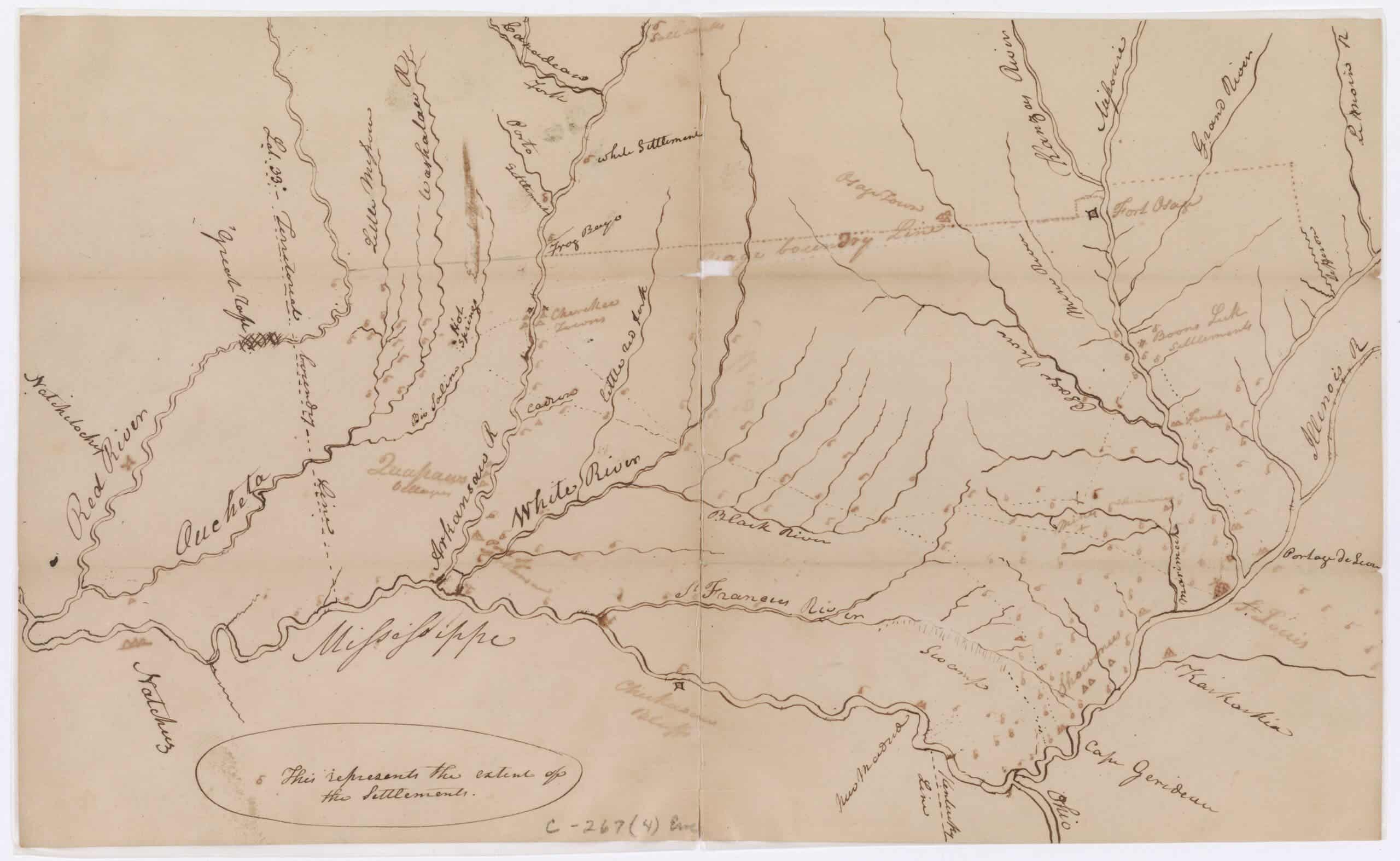
The map depicts the basic geography of the Osage Treaty of 1808, a key moment in US history. Back then, the Osage Nation gave all their land east of Fort Clark in Missouri and Arkansas to the United States. The indigenous communities, affected by this land grabbing episode, ended up siding with the British in the War of 1812.
Lee, a Cambridge historian, found the map filed in the secretary of war’s correspondence archive, filed under the authorship of Captain Eli Clemson. He decided to investigate this further, finding out that the map had actually been drawn by William Clark, who was the governor of Missouri at the time of the Osage Treaty.
But this wasn’t the only finding. Lee also decoded the significance of an unlabeled line on the map. After failing to purchase land from the Sauks, Meskwakis, and Iowas in 1815, Clark redrew the lines of the Osage Treaty – adding 10.5 million acres to public land by claiming the US had already bought this region from the Osages in the 1808 treaty. Clark cheated.
“It’s the closest document we have to an admission in Clark’s own hand that he unilaterally moved a treaty line to aid settlers then invading Sauk, Meskwaki, and Iowa territory. I was stunned, not that Clark had done this, but that this piece of evidence—which is about as close as we’re going to get to catching him red-handed—was just sitting there hidden in plain sight,” Lee told ZME Science.
Understanding the map
Lee said he was convinced that this was a missing Clark map after spending a few hours examining it. The establishment dates of features on the map like several US settlements not founded until after 1808 cast doubt on Clemson’s authorship. One feature — a saltworks in what is today Oklahoma — wasn’t even established until after Clemson’s tour of duty in the region ended.
But figuring out that Clemson didn’t draw it—that it was misfiled and misattributed—was only half of the problem, Lee said. Although it’s unsigned and undated, several clues point to Clark. He was a horrendous speller and this became evident on the map, in which Clark’s map spells Shawnees as “Showonees”. This same mistake is evident in other letters and maps by him.
The dead giveaway, however, is a line on the map between the Arkansas and Red Rivers that ties this map firmly to a letter Clark wrote in 1816 where he proposed obtaining a Quapaw land cession by extending an Osage treaty line, Lee explains. This proposal never actually happened. It was only even floated in this letter, Lee explained.
“Most Americans learn about Clark for the three years he spent with the Corps of Discovery (1804-1806) and few know that he then spent over 30 years as the leading architect of Indigenous dispossession in the trans-Mississippi West. As historians have started to look closely at his whole career, the picture has become more balanced and less flattering. This new map adds a new level of detail,” Lee told ZME Science.
This research comes from ongoing work on a book examining how Indigenous dispossession by treaty shaped the development of the United States in the nineteenth century. Clark will figure prominently, as will other unstudied maps by him and others. For now, the study on the map’s finding was published in the journal William and Mary Quarterly.


