NASA presents first insights from Martian earthquakes
NASA InSight mission reveals tantalizing clues about Mars' subsurface.
A whopping 174 seismic events have been recorded by the lander’s seismometer on Mars, indicating an active plate with intriguing tectonics.
If we once thought Mars was a barren and boring place, there’s no reason to believe that now. Not only did the Red Planet host liquid water and an atmosphere, it still seems to have some semblance of a tectonic system.
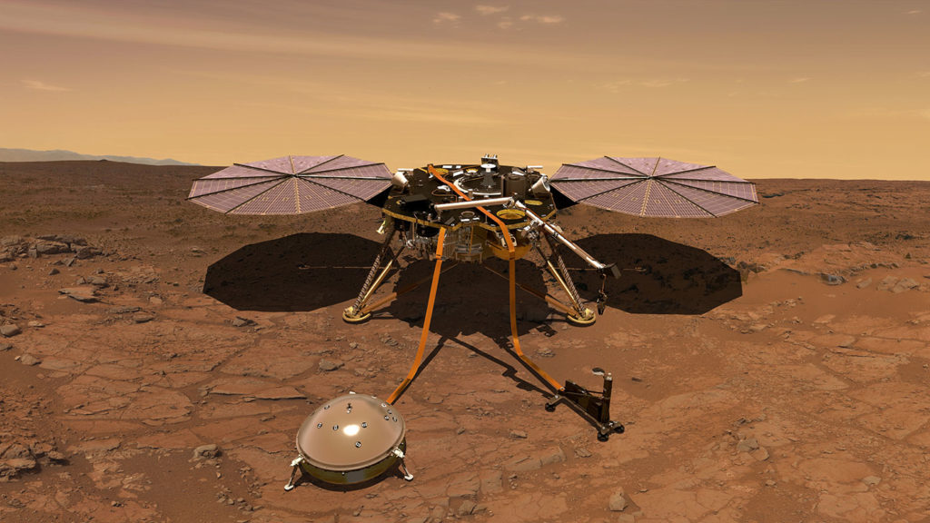
The Interior Exploration using Seismic Investigations, Geodesy and Heat Transport (or InSight) mission was launched in 2018 to study the subsurface of the planet. The plan was fairly straightforward: send a lander on Mars, and deploy a few geological sensors, including a seismometer and a thermal probe. The goal is to study Mars’ early geological evolution, understanding how it formed and evolved, and whether it is active today.
Seismic sensors offered invaluable information here on Earth. Most of what we know about the Earth’s depths comes from seismic information — the way seismic waves propagate through the crust, mantle, and core, can help us understand their size and physical properties. While a single sensor would be limited in scope, it would still offer an unprecedented view into the Martian depths.
“This is the first mission focused on taking direct geophysical measurements of any planet besides Earth, and it’s given us our first real understanding of Mars’ interior structure and geological processes,” said Nicholas Schmerr, an assistant professor of geology at UMD and a co-author of the study. “These data are helping us understand how the planet works, its rate of seismicity, how active it is and where it’s active.”
In a flurry of new papers, NASA researchers presented the first findings from InSight, including the identification and study of almost two hundred earthquakes.
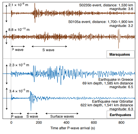
The waveforms of the seismic waves showed that most earthquakes were high-frequency and low-intensity.
However, over 20 earthquakes had a magnitude of 3-4, and several were low-frequency (potentially indicative of tectonic movement). Three showed wave patterns distinctly similar to tectonic quakes on Earth. Researchers believe that they might be able to identify the source of these earthquakes.
“These low-frequency events were really exciting, because we know how to analyze them and extract information about subsurface structure,” said Vedran Lekic, an associate professor of geology at UMD and a co-author of the study. “Based on how the different waves propagate through the crust, we can identify geologic layers within the planet and determine the distance and location to the source of the quakes.”
In addition to the seismometer, the mission also deployed the first ground-based magnetometer, capable of studying the planet’s crustal magnetic field. Although satellite missions have also measured crustal magnetization, land-based surveys can provide more detailed and precise information about the planet’s localized magnetic field. Measurements showed a stronger-than-anticipated magnetic field, consistent with an Earth-like ancient dynamo field that would have been capable of supporting an atmosphere.
This further emphasizes Mars’ past as an active, Earth-like planet.
The seismometer’s delicate sensors also provided important information about Martian weather. For instance, when strong winds lift the ground significantly, the seismometer registers a tilt in the substrate. Researchers found that these winds produce a distinct seismic signature, which, along with direct weather information, can paint a picture of daily meteorological activity.
The team reports that the winds start picking up steam at midnight, becoming stronger through the early morning, as cooler air rolls down from the highlands to the plain where the lander is carrying out its activity. This wind activity produces enough noise to mask the seismic activity during the day. From late evening until midnight, conditions become very quiet around the lander, and it’s during the night — and it’s in that period that almost all the seismic events were detected. It’s almost certain that the activity continues outside thous hours, but there’s just too much noise to detect the seismic waves.
“What is so spectacular about this data is that it gives us this beautifully poetic picture of what a day is actually like on another planet,” Lekic said.
The research papers, “First constraints on the shallow elastic and anelastic structure of Mars from InSight seismic data,” P.Lognonné et al., and “Initial results from the InSight mission on Mars” by W. Banerdt et al., were published as part of a special issue of the journal Nature Geoscience released on February 24, 2020.