Little-known 2012 volcanic eruption was actually the largest in over a century, new data shows
It was huge, and we might have missed it completely!
In July 2012, geologists noted the eruption of a previously little-known volcanic area called Havre Seamount, located off the coast of New Zealand. Now, after analyzing the data more thoroughly, they say it was one of the largest eruptions in modern history — we just didn’t realize it because it took place underwater.
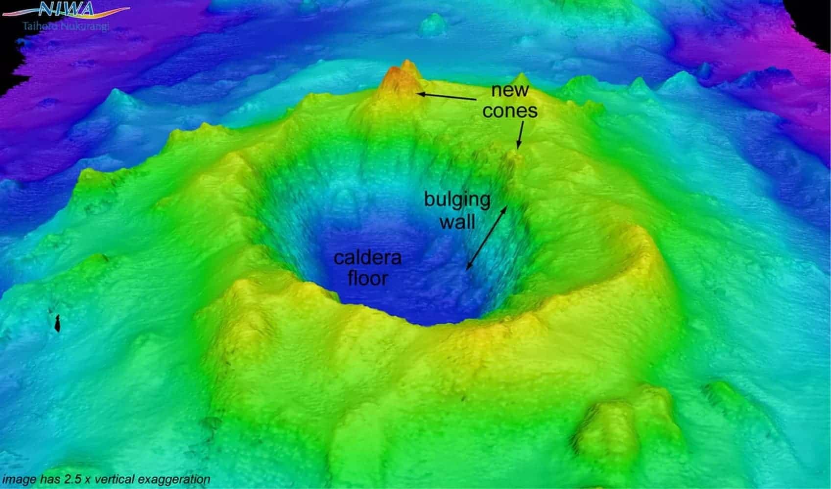
An echosounder image showing the undersea volcano called Havre Seamount, including a new cone that formed during the July 2012 eruption. Credit: NIWA/GNS Science.
The eruption of the Havre Seamount was not initially noticed by scientists. Havre Seamount was only discovered in 2002, and researchers weren’t even aware that the area was volcanic. But as it erupted, it offered passengers on an airline flight over the Southwest Pacific an unusual display: a raft of porous, floating rock (known as pumice), as big as 150 square miles — that’s 50% bigger than the surface of Paris.
Maggie de Grau was a passenger on that flight. Like many others on that plane, she took photos of the strange phenomenon, which she proceeded to email to Dr. Scott Bryan, a senior research fellow at Queensland University of Technology. The raft grew even more, and Bryan contacted some of his colleagues, ultimately discovering that a few military pilots had also witnessed the event days and weeks after the eruption. An officer in the Royal Australian Navy was quoted as saying that it was “the weirdest thing [he had] seen in 18 years at sea.” It was at that point that scientists knew they had something much bigger on their hands.
“We knew it was a large-scale eruption, approximately equivalent to the biggest eruption we’ve seen on land in the 20th Century,” said Rebecca Carey, a volcanologist at University of Tasmania and Co-Chief Scientist on the expedition.

NASA image of Havre Seamount eruption and initial formation of pumice raft.
After the pumice raft was detected, the gears started to turn. Seismologists quickly pinpointed and described a cluster of earthquakes consistent with magma rising into a magma chamber prior to eruption. Retrospective analysis of satellite imagery also revealed the pumice, and so, a mission to map the seafloor topography and monitor any changes was launched in 2015.
Using a pair of autonomous underwater vehicles, they were able to dive beneath the surface of the water and see what neither the earthquakes nor the satellite imagery could reveal: what the eruption looked like. Now, these results have finally been published.
“When we used the submersible vehicles to go down to the seafloor in 2015, we were able to see a vast array of new volcanic products, such as 14 different lava flows at depths of between 1,220 and 650 metres beneath sea level,” says Rebecca Carey, lead researcher on the study, which has been published in the journal Science Advances.

High-resolution seafloor topography of the Havre caldera mapped by the autonomous underwater vehicle (AUV) Sentry shows the lava that erupted in 2012 in red. The volcano is nearly a mile deep (1,519 meters). The top of the volcano is at 650 meters below sea level. Credit: Rebecca Carey, University of Tasmania, Adam Soule, WHOI/
As it turns out, the Havre eruption has some intriguing particularities. For starters, it’s the largest deep-ocean eruption in recorded history and one of very few recorded submarine eruptions involving rhyolite magma — a type of silica-rich magma. Eruptions involving this type of magma are violent and explosive, but most of what we know about them comes from rock records. Scientists have never before been able to analyze such an eruption shortly after it occurred.
The eruption was also more complex — it’s not just one volcano cone that erupted. It consisted of lava from 14 volcanic vent sites between 900 and 1220 meters (3000 and 4000 feet) below the surface. The sheer size of the eruption was also impressive: 1.5 times larger than the 1980 eruption of Mount St. Helens. But unlike that eruption, this one didn’t produce an explosive tower due to water pressure. The water pushing down on the lava suppressed most of the explosivity we would have seen if the eruption had taken place on land. However, rather interestingly, lava flows look exactly like how they would if they were on land; but unlike a land eruption, 75 percent of the lava floated to the surface and drifted away with the currents.
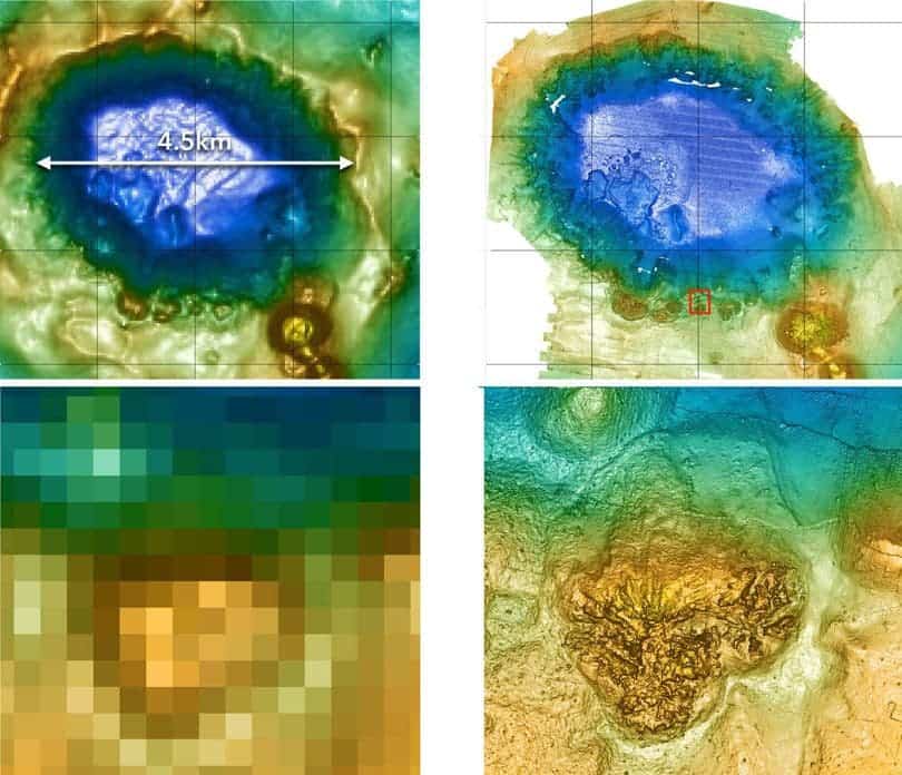
Images of ship-based mapping compared with autonomous vehicle mapping. Credits: University of Tasmania, Australia.
It’s not surprising at all that geologists didn’t grasp the full scale of this eruption at first. More than 70 percent of the planet’s volcanic activity happens underwater, but the details are often hidden to us. Getting the chance to explore this eruption hands on is a rare opportunity.
However, while for geologists this is a thrilling discovery, wildlife may have been greatly affected by the scale of the eruption. Carey says biologists are “very interested to learn more about how species recolonise, and where those new species are coming from”. All in all, they brought back a trove of data which will take years to analyze. It will take a long time before we finally grasp the ramifications of the 2012 Havre eruption.
“There is a decade worth of interdisciplinary science to do based on our 2015 voyage data and samples. It’s very exciting to marry the geosciences with other scientific disciplines addressing novel research questions,” concludes Carey
Journal Reference: Rebecca Carey et al. The largest deep-ocean silicic volcanic eruption of the past century.