Google Maps adds COVID-19 layer to alert about cases
The tool will be available all over the world on mobile phones.
From now on, the popular navigation application Google Maps will report on COVID-19 outbreaks that occur around the world, with geographic information on the cases. The new functionality was added for users of Android and iOS operating systems as an extra layer on top of the maps.
More than one billion people use Google Maps for essential information on how to get from place to place. Amid the pandemic, the app has already included several new features such as the location checkpoints in driving navigation, COVID-19 alters in transit, as well as when individual businesses see the most visitors, helping people to stay safe.
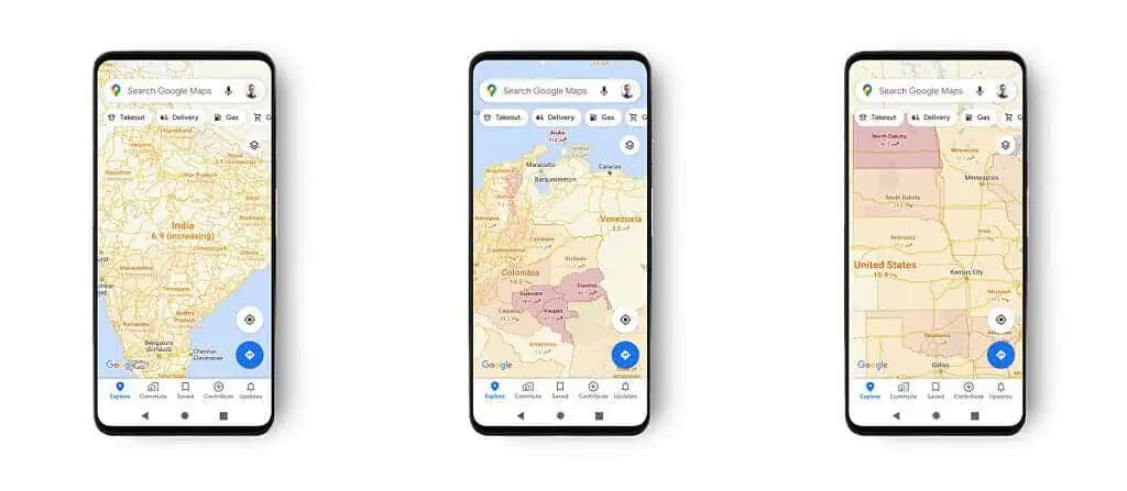
Now, the novel feature will show how many COVID-19 cases there are in particular geographic regions. The information displayed is the average number of cases per 100,000 inhabitants in the last seven days for the area being viewed, with a label indicating if the trend in new cases is upward or not. The tool will be available for 220 countries.
Using it is quite simple. First, make sure you have the latest version of the Google Maps app, as you’ll need to update to it for the information to be visible (it might take a few days for the update to be available, depending on where you live). Once you get the update, open Google Maps, tap the layers button, and chose “COVID-19” info layer.
To help you navigate the world safely, you’ll start seeing information about new COVID cases in an area with data from sources like @nytimes, @JohnsHopkins, & @Wikipedia in a new layer on Maps.
Rolling out on iOS & Android, with more ways to stay up-to-date coming soon. 👍 pic.twitter.com/iWB02T0aAB
— Google Maps (@googlemaps) September 23, 2020
Google Maps Product Manager Sujoy Banerjee announced the new feature in a post on Google’s website. He said the goal is to help users “make decisions about where to go and what to do with the best information,” and get to their destinations “in the safest and most efficient way possible.”
The data included in the new COVID-19 layer comes from multiple sources, including Johns Hopkins University, the newspaper The New York Times, and Wikipedia, which in turn collect data from health entities such as the World Health Organization, health ministries, and hospitals around the world.
While this sounds good, there are a few issues to consider. Wikipedia’s COVID-19 coronavirus data will depend on who happens to log on to Wikipedia and enter the information onto the corresponding page, for example. This means the accuracy of Google Maps will depend on what kind of COVID-19 data is being reported where.
At the same time, identifying cases depends on testing. It’s not enough to just know the number of tests being done, you also need to know where and how often testing is being done and on whom. Without this, it’s difficult to know the accuracy of case reporting around the world.
There could also be reporting delays. Once you get tested, the results have to somehow make their way through to the proper public health authorities. Plus, there’s the granularity of the data. If cases are being reported at a county level, the data won’t be able to tell you much about which specific streets to avoid.
Tech companies have been trying to collaborate amid the pandemic. Apple displayed testing centers and shared mobility data through Apple Maps, while Facebook launched a COVID-19 information center to provide information. However, companies also struggle with misinformation. A study showed Google funneled over $19 million to websites spreading misinformation about the pandemic.


