63 trillion gallons of groundwater lost in 2013 drought in Western US
A new study shows that last an incredible 63 trillion gallons of groundwater were lost in the Western US alone – so much that it’s actually causing the ground level to rise. The Earth has lifted up about 0.16 inches over the last 18 months in the area, and up to 0.6 inches in the Californian […]
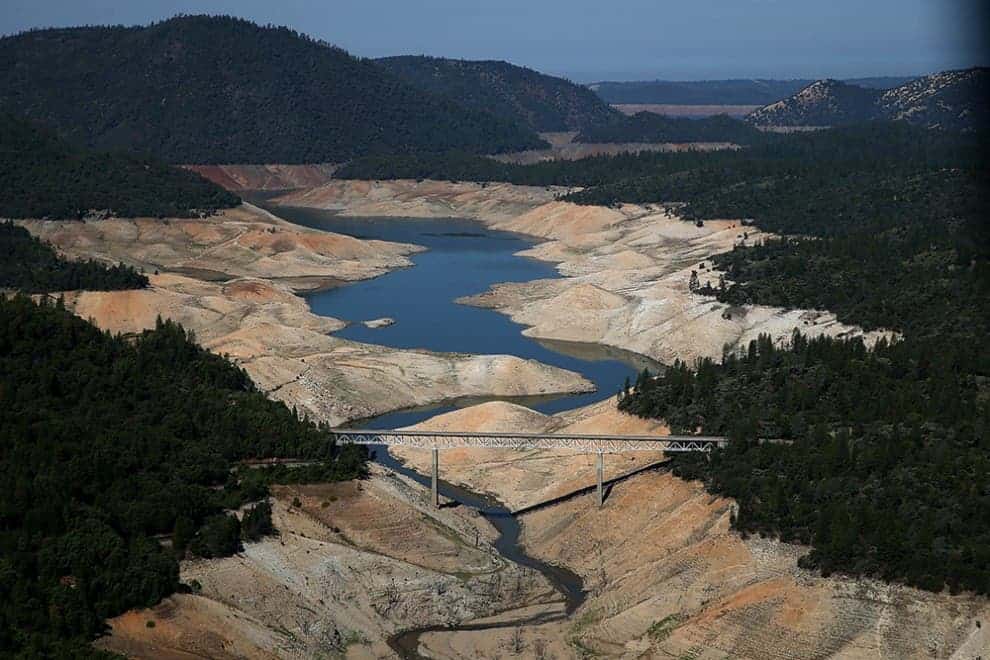
A snake-like trickle of water flows underneath Lake Oroville’s Enterprise Bridge. Image credits: Justin Sullivan/Getty Images
A new study shows that last an incredible 63 trillion gallons of groundwater were lost in the Western US alone – so much that it’s actually causing the ground level to rise. The Earth has lifted up about 0.16 inches over the last 18 months in the area, and up to 0.6 inches in the Californian mountains.
California’s drought is already reaching chronic levels, affecting the state’s lakes and reservoirs. This is no longer just a bad year or a freak event – it’s a trend, it’s what will constantly happen from now on for years and years to come. Researchers from UC San Diego’s Scripps Institution of Oceanography and the U.S. Geological Survey estimate that in 2013 alone 63 trillion gallons were lost – the equivalent of covering the entire US west of the Rockies with 4 inches of water.
“We found that it’s most severe in California, particularly in the Sierras,” said coauthor Duncan Agnew, professor of geophysics at UC San Diego’s Scripps Institution of Oceanography. “It’s predominantly in the Coast Ranges and the Sierras showing the most uplift, and hence, that’s where we believe is the largest water loss.”
You could easily argue that having such a big population in a desert area such as California wasn’t a good idea in the first place. But now, California has some 10% of the entire US population, and the number is continuously growing – this can only translate into more drought, more lost water, until a critical point is reached: a crisis.

Water levels in 2011 and 2014. Photos: Paul Hames/California Department of Water Resources (left); Justin Sullivan/Getty Images (right)
Scientists got to this number after analyzing data collected from hundreds of GPS sensors across the western United States, installed primarily to detect small changes in the ground due to earthquakes. But the GPS devices can also be used to detect very small changes in elevation. Groundwater is heavy, and its weight depresses the Earth’s upper crust. If you remove the groundwater, you remove its weight, and the surface of the Earth springs up a tiny bit. By calculating how much the ground has risen with GPS sensors, scientists were able to calculate the volume of removed water. The highest lift occurred in Californian mountains, because that’s where most of the water is.
“You can only lose water where there’s water to lose,” Agnew said.
Water conservation is a major problem in California, as in many parts of Western US, with no solution in sight as long as population and waste continues to rise.